|
search place name
|
||
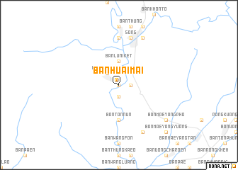
Ban Huai Mai (Phrae, Thailand)Ban Huai Mai is a town in the Phrae region of Thailand. An overview map of the region around Ban Huai Mai is displayed below.
regional and 3d topo map of Ban Huai Mai, Thailand ::
Ban Huai Mai airports ::
The nearest airport is PRH - Phrae, located 29.6 km south of Ban Huai Mai.
Other airports nearby include LPT - Lampang (71.5 km west), PHS - Phitsanulok (179.4 km south), LOE - Loei (196.1 km south east), LPQ - Luang Prabang Luang Phabang Intl (267.4 km north east), Nearby towns ::
Ban Huai Khon (0.0km north) //
Ban Thung Nao (1.8km east) //
Ban Pa Daeng (1.9km south) //
Ban Rong Than (2.6km north west) //
Ban Lu (3.7km north) //
Ban Lu Niket (3.7km north) //
Ban Ton Nun (5.6km south) //
Ban Nun Tai (7.4km north) //
Song (7.6km north) //
Ban Lap Lae (7.6km north) //
Klāng Song (7.6km north) //
Ban Mae Tha (8.2km south east) //
Ban Lao (8.2km north east) //
Ban Mae Yang Pho (9.0km south east) //
Ban Mae Yang Yuang (10.2km south east) //
[all distances 'as the bird flies' and approximate]  Places with similar names to Ban Huai Mai, Thailand ::
// Beni Hayyoum (MA)
// Beienheim (DE)
// Boinham (DE)
// Benham (US)
// Ban A Ham (TH)
// Ban A Ham (TH)
// Ban Hom (TH)
// Ban Hom (TH)
// Ban Hom (TH)
// Ban Huai Ma (TH)
Disclaimer :: Information on this page comes without warranty of any kind |
||
|
Where is Ban Huai Mai? Elevation and coordinates ::
Latitude (lat): 18°24'0"N Longitude (lon): 100°10'0"E
Elevation (approx.): 171m (map arrows pan, magnifying glasses zoom) |
||
|
Visiting Ban Huai Mai? Hotel/Accommodation ::
Book a hotel in Ban Huai Mai Travel Guide ::
Buy a travel guide for Thailand rental cars ::
car rental offers GPS waypoint ::
download a GPX waypoint (PoI) of Ban Huai Mai for your GPS receiver
|
||