|
search place name
|
||
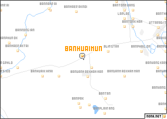
Ban Huai Mun (Uttaradit, Thailand)Ban Huai Mun is a town in the Uttaradit region of Thailand. An overview map of the region around Ban Huai Mun is displayed below.
regional and 3d topo map of Ban Huai Mun, Thailand ::
Ban Huai Mun airports ::
The nearest airport is PRH - Phrae, located 66.6 km north of Ban Huai Mun.
Other airports nearby include LPT - Lampang (91.1 km north west), PHS - Phitsanulok (93.5 km south), LOE - Loei (188.7 km east), Nearby towns ::
Ban Huai Khamin (2.6km south east) //
Ban Dan Mae Kham Man (4.0km south) //
Ban Taling Tam (5.6km east) //
Ban Dong Khu (6.5km south west) //
Ban Tan (10.0km south east) //
[all distances 'as the bird flies' and approximate] 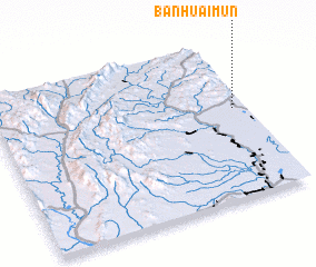 Places with similar names to Ban Huai Mun, Thailand ::
// Ban Huai Manao (TH)
// Ban Huai Men (TH)
// Ban Huai Mun (TH)
// Ban Huai Mun (TH)
// Ban Hua Mi Na (TH)
// Ban Hua Mon (TH)
// Ban Houayman (LA)
// Ban Houayman (LA)
// Ban Houaymanai (LA)
// Ban Houayma-Nua (LA)
Disclaimer :: Information on this page comes without warranty of any kind |
||
|
Where is Ban Huai Mun? Elevation and coordinates ::
Latitude (lat): 17°34'0"N Longitude (lon): 99°57'0"E
Elevation (approx.): 73m (map arrows pan, magnifying glasses zoom) |
||
|
Visiting Ban Huai Mun? Hotel/Accommodation ::
Book a hotel in Ban Huai Mun Travel Guide ::
Buy a travel guide for Thailand rental cars ::
car rental offers GPS waypoint ::
download a GPX waypoint (PoI) of Ban Huai Mun for your GPS receiver
|
||