|
search place name
|
||
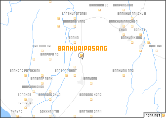
Ban Huai Pa Sang (Phayao, Thailand)Ban Huai Pa Sang is a town in the Phayao region of Thailand. An overview map of the region around Ban Huai Pa Sang is displayed below.
regional and 3d topo map of Ban Huai Pa Sang, Thailand ::
Ban Huai Pa Sang airports ::
The nearest airport is LPT - Lampang, located 126.0 km south west of Ban Huai Pa Sang.
Other airports nearby include PRH - Phrae (128.0 km south), THL - Tachilek Tachileik (133.4 km north), MOG - Mong Hsat (159.8 km north west), LOE - Loei (270.0 km south east), Nearby towns ::
Ban Dok Khem (2.5km south west) //
Ban Huai Ton Tum (2.5km north west) //
Ban Bua Sathan (4.1km south west) //
Ban Mai (4.1km north west) //
Ban San Pa Hat (5.1km south west) //
Ban Dong (5.8km south) //
Ban Pa Fang (7.0km west) //
Ban Pang Kho (7.6km north) //
Ban Pang Pa Pom (7.6km north) //
Ban Rong Yang (7.6km north) //
Ban Kluai Khrai (9.1km north west) //
Ban Mae Ing (1) (10.2km south west) //
[all distances 'as the bird flies' and approximate] 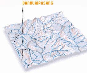 Places with similar names to Ban Huai Pa Sang, Thailand :: Disclaimer :: Information on this page comes without warranty of any kind |
||
|
Where is Ban Huai Pa Sang? Elevation and coordinates ::
Latitude (lat): 19°17'0"N Longitude (lon): 100°3'0"E
Elevation (approx.): 461m (map arrows pan, magnifying glasses zoom) |
||
|
Visiting Ban Huai Pa Sang? Hotel/Accommodation ::
Book a hotel in Ban Huai Pa Sang Travel Guide ::
Buy a travel guide for Thailand rental cars ::
car rental offers GPS waypoint ::
download a GPX waypoint (PoI) of Ban Huai Pa Sang for your GPS receiver
|
||