|
search place name
|
||
Ban Huai Yot (Surat Thani, Thailand)Ban Huai Yot is a town in the Surat Thani region of Thailand. An overview map of the region around Ban Huai Yot is displayed below.
regional and 3d topo map of Ban Huai Yot, Thailand ::

Ban Huai Yot airports ::
The nearest airport is NST - Nakhon Si Thammarat Cha Ian, located 84.0 km east of Ban Huai Yot.
Other airports nearby include HKT - Phuket Intl (121.0 km south west), TST - Trang (140.1 km south), HDY - Songkhla Hat Yai Intl (235.1 km south east), PAN - Pattani (300.8 km south east), Nearby towns ::
Ban Phuang Phrom Nakhon (3.7km north) //
Ban Han Dam (4.1km south east) //
Ban Khlong Lo (4.1km south east) //
Ban Huai Bon (5.2km south east) //
Ban Hua Khao (5.2km south east) //
Ban Prachon (5.5km east) //
Ban Thepha (5.6km north) //
Ban Mua Ket (5.8km east) //
Ban Huai Mut (6.7km north west) //
Ban Tha Chi (6.6km north east) //
Ban Ammarat (7.6km north) //
Ban Nam Phu (8.2km north east) //
Ban Wiang (10.4km south east) //
[all distances 'as the bird flies' and approximate] 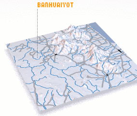 Places with similar names to Ban Huai Yot, Thailand ::
// Ban Huai Yot (TH)
// Ban Hua Yot (TH)
// Ban Houay-At (LA)
// Ban Houay-Èt (LA)
// Ban Houay-Out (LA)
// Ban Houay-Uat (LA)
// Ban Houayuat (LA)
Disclaimer :: Information on this page comes without warranty of any kind |
||
|
Where is Ban Huai Yot? Elevation and coordinates ::
Latitude (lat): 8°43'0"N Longitude (lon): 99°14'0"E
Elevation (approx.): 33m (map arrows pan, magnifying glasses zoom) |
||
|
Visiting Ban Huai Yot? Hotel/Accommodation ::
Book a hotel in Ban Huai Yot Travel Guide ::
Buy a travel guide for Thailand rental cars ::
car rental offers GPS waypoint ::
download a GPX waypoint (PoI) of Ban Huai Yot for your GPS receiver
|
||