|
search place name
|
||
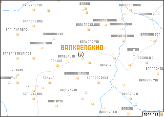
Ban Kaeng Kho (Ubon Ratchathani, Thailand)Ban Kaeng Kho is a town in the Ubon Ratchathani region of Thailand. An overview map of the region around Ban Kaeng Kho is displayed below.
regional and 3d topo map of Ban Kaeng Kho, Thailand ::
Ban Kaeng Kho airports ::
The nearest airport is PKZ - Pakse, located 99.0 km north east of Ban Kaeng Kho.
Other airports nearby include REP - Siem-reap Siem Reap (186.4 km south west), Nearby towns ::
Ban Ta Luak (0.0km north) //
Ban Khum (0.0km north) //
Ban Kaeng Ton (2.0km south east) //
Ban Yang Yai (3.3km north east) //
Ban Bu Puai (3.3km west) //
Ban Na Samakkhi (4.6km south) //
Nam Yun (5.7km west) //
Ban Puai (6.2km south east) //
Ban Nong Phot (6.6km south east) //
Ban Yang Klang (6.8km north) //
Ban Dong Krachu (6.9km east) //
Ban Dong Kasu (7.2km east) //
Ban Dong Kasu (7.2km east) //
Ban Phon Thong (7.8km south) //
Ban Kao Kham (7.7km north west) //
Ban Sam Wai (8.8km south) //
Nam Yun (9.1km south west) //
Ban Non Sawang (9.2km north east) //
[all distances 'as the bird flies' and approximate] 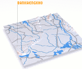 Places with similar names to Ban Kaeng Kho, Thailand ::
// Ban Kaeng Khoi (TH)
// Ban Kèngkha (LA)
// Ban Kèngkhai (LA)
// Ban Kèngkhai (LA)
// Ban Kèng Khay (LA)
// Ban Kèngkhoay (LA)
// Ban Kongkhao (LA)
Disclaimer :: Information on this page comes without warranty of any kind |
||
|
Where is Ban Kaeng Kho? Elevation and coordinates ::
Latitude (lat): 14°33'0"N Longitude (lon): 105°5'0"E
Elevation (approx.): 185m (map arrows pan, magnifying glasses zoom) |
||
|
Visiting Ban Kaeng Kho? Hotel/Accommodation ::
Book a hotel in Ban Kaeng Kho Travel Guide ::
Buy a travel guide for Thailand rental cars ::
car rental offers GPS waypoint ::
download a GPX waypoint (PoI) of Ban Kaeng Kho for your GPS receiver
|
||