|
search place name
|
||
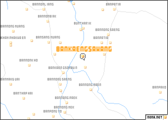
Ban Kaeng Sawang (Ubon Ratchathani, Thailand)Ban Kaeng Sawang is a town in the Ubon Ratchathani region of Thailand. An overview map of the region around Ban Kaeng Sawang is displayed below.
regional and 3d topo map of Ban Kaeng Sawang, Thailand ::
Ban Kaeng Sawang airports ::
The nearest airport is PKZ - Pakse, located 62.2 km north east of Ban Kaeng Sawang.
Other airports nearby include ZVK - Savannakhet (217.3 km north), REP - Siem-reap Siem Reap (224.1 km south west), Nearby towns ::
Ban Non Bok (1.7km south) //
Ban Hua Khae (3.2km north west) //
Ban Non Noi (4.6km east) //
Ban Kaeng Sombun (5.3km south west) //
Ban Pa Tia (5.5km north east) //
Amphoe Bunthark (6.4km north west) //
Ban Kut Chiak (6.4km north west) //
Ban Lak Pai (6.4km north west) //
Ban Huai Po (6.5km west) //
Ban Bua Ngam (6.8km north) //
Ban Nong Paen (6.8km south) //
Ban Nong Saeng (6.9km north east) //
Buntharik (7.1km north) //
Ban Nong Saeng (7.4km south west) //
Ban Non Bok (7.4km south west) //
Ban Nong Saeng (7.7km north east) //
Ban Huai Kha (8.5km south west) //
Ban Sang Muang (8.6km north west) //
Ban Non Bak (11.6km north west) //
[all distances 'as the bird flies' and approximate] 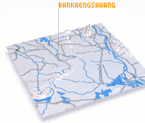 Places with similar names to Ban Kaeng Sawang, Thailand :: Disclaimer :: Information on this page comes without warranty of any kind |
||
|
Where is Ban Kaeng Sawang? Elevation and coordinates ::
Latitude (lat): 14°41'54"N Longitude (lon): 105°24'50"E
Elevation (approx.): 169m (map arrows pan, magnifying glasses zoom) |
||
|
Visiting Ban Kaeng Sawang? Hotel/Accommodation ::
Book a hotel in Ban Kaeng Sawang Travel Guide ::
Buy a travel guide for Thailand rental cars ::
car rental offers GPS waypoint ::
download a GPX waypoint (PoI) of Ban Kaeng Sawang for your GPS receiver
|
||