|
search place name
|
||
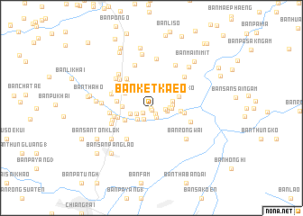
Ban Ket Kaeo (Chiang Rai, Thailand)Ban Ket Kaeo is a town in the Chiang Rai region of Thailand. An overview map of the region around Ban Ket Kaeo is displayed below.
regional and 3d topo map of Ban Ket Kaeo, Thailand ::
Ban Ket Kaeo airports ::
The nearest airport is THL - Tachilek Tachileik, located 51.7 km north of Ban Ket Kaeo.
Other airports nearby include MOG - Mong Hsat (87.9 km north west), KET - Kengtung (145.0 km north), LPT - Lampang (198.0 km south), PRH - Phrae (210.4 km south), Nearby towns ::
Ban Lao Phanawan (0.1km south) //
Ban San Rai (0.3km south) //
Ban Mae Khao Tom (0.9km south east) //
Ban San Chang (1.1km south west) //
Ban San Ton Kok (1.1km south west) //
Ban San Ton Haen (1.3km south east) //
Ban Thung Yao (1.7km south west) //
Ban Thung (1.7km east) //
Ban Doi Thewa (1.8km east) //
Ban San Ton Kok (1.9km south west) //
Ban Kosin Nimit (2.1km east) //
Ban Hua Fai (2.2km south west) //
Ban Nong Laeng (2.3km east) //
Ban Nong Bua Daeng (2.5km east) //
Ban San Ton Muang (2.5km west) //
Ban Rai (2.6km east) //
Ban Muang Kham (3.4km south west) //
Ban Pa Sang (3.4km west) //
Ban Rong Ko (3.5km north east) //
Ban San Ton Faen (3.5km east) //
Ban Takhian Dam (3.6km north west) //
Ban Tha Ko Hai (3.9km east) //
Ban Pa Toem (4.2km north west) //
Ban Dong (4.1km west) //
Ban Khua Tae (4.1km west) //
Ban Thung (4.5km west) //
Ban Huai Pa Phlu (4.6km north west) //
Ban Huai Phlu (4.7km north west) //
Ban Nang Lae (4.8km south west) //
[all distances 'as the bird flies' and approximate]  Places with similar names to Ban Ket Kaeo, Thailand ::
// Ban Kai Dak (TH)
// Ban Kutakai (TH)
// Ban Kut Kae (TH)
// Ban Kut Kua (TH)
// Ban Kut Ta Kai (TH)
// Bangataka (BF)
// Binnguédougou (BF)
// Bankodougou (GN)
// Ban Katok (LA)
// Ban Katôk (LA)
Disclaimer :: Information on this page comes without warranty of any kind |
||
|
Where is Ban Ket Kaeo? Elevation and coordinates ::
Latitude (lat): 20°1'3"N Longitude (lon): 99°54'40"E
Elevation (approx.): 395m (map arrows pan, magnifying glasses zoom) |
||
|
Visiting Ban Ket Kaeo? Hotel/Accommodation ::
Book a hotel in Ban Ket Kaeo Travel Guide ::
Buy a travel guide for Thailand rental cars ::
car rental offers GPS waypoint ::
download a GPX waypoint (PoI) of Ban Ket Kaeo for your GPS receiver
|
||