|
search place name
|
||
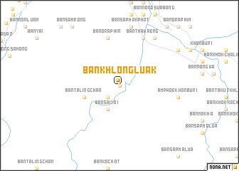
Ban Khlong Luak (Nakhon Ratchasima, Thailand)Ban Khlong Luak is a town in the Nakhon Ratchasima region of Thailand. An overview map of the region around Ban Khlong Luak is displayed below.
regional and 3d topo map of Ban Khlong Luak, Thailand ::
Ban Khlong Luak airports ::
The nearest airport is NAK - Nakhon Ratchasima Khorat, located 52.1 km north of Ban Khlong Luak.
Other airports nearby include BKK - Bangkok Intl (175.8 km west), REP - Siem-reap Siem Reap (215.8 km south east), UTP - Rayong U Taphao Intl (232.3 km south west), Nearby towns ::
Ban Na (1) (0.0km north) //
Ban Nong Sano (2.6km south west) //
Ban Ko Chot (2.6km south west) //
Ban Na (2.6km south west) //
Ban Sai Yoi (4.1km south west) //
Ban Taling Chan (5.7km west) //
Ban Khon Buri (7.6km north) //
Ban Non Po Daeng (7.6km north) //
Ban Oraphin (7.6km north) //
Ban Tha Kaeng (8.2km north east) //
Ban Nong Sano (8.2km north east) //
Ban Chorakhe Hin (9.2km north east) //
[all distances 'as the bird flies' and approximate] 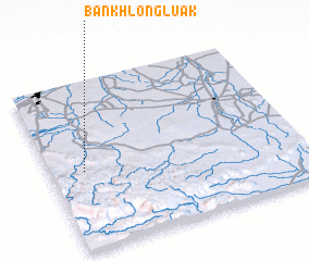 Places with similar names to Ban Khlong Luak, Thailand ::
// Ban Khlong Lek (TH)
Disclaimer :: Information on this page comes without warranty of any kind |
||
|
Where is Ban Khlong Luak? Elevation and coordinates ::
Latitude (lat): 14°28'0"N Longitude (lon): 102°8'0"E
Elevation (approx.): 219m (map arrows pan, magnifying glasses zoom) |
||
|
Visiting Ban Khlong Luak? Hotel/Accommodation ::
Book a hotel in Ban Khlong Luak Travel Guide ::
Buy a travel guide for Thailand rental cars ::
car rental offers GPS waypoint ::
download a GPX waypoint (PoI) of Ban Khlong Luak for your GPS receiver
|
||