|
search place name
|
||
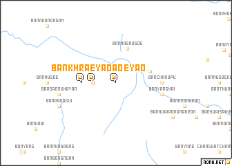
Ban Khrae Yao (Chiang Rai, Thailand)Ban Khrae Yao is a town in the Chiang Rai region of Thailand. An overview map of the region around Ban Khrae Yao is displayed below.
regional and 3d topo map of Ban Khrae Yao, Thailand ::
Ban Khrae Yao airports ::
The nearest airport is THL - Tachilek Tachileik, located 65.6 km north east of Ban Khrae Yao.
Other airports nearby include MOG - Mong Hsat (69.1 km north west), KET - Kengtung (146.0 km north), LPT - Lampang (189.8 km south), PRH - Phrae (213.4 km south), Nearby towns ::
Ban Mai Musoe (3.5km west) //
Ban Chak Haen La (3.5km west) //
Ban Khrae Yao (3.5km west) //
Ban Khrae Yao (5.2km west) //
Ban Mae Mu Soe (5.8km north) //
Ban Chae Chai (5.5km east) //
Ban Ai Bu (7.0km east) //
Ban Cha Ku Pu (7.0km east) //
Ban Yang Mai (7.2km east) //
[all distances 'as the bird flies' and approximate] 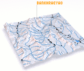 Places with similar names to Ban Khrae Yao, Thailand ::
// Ban Khrae Yao (TH)
// Ban Khrae Yao (TH)
// Ban Ko Rai Yai (TH)
// Banguruye (CD)
// Binakarya (ID)
Disclaimer :: Information on this page comes without warranty of any kind |
||
|
Where is Ban Khrae Yao? Elevation and coordinates ::
Latitude (lat): 19°59'0"N Longitude (lon): 99°36'0"E
Elevation (approx.): 600m (map arrows pan, magnifying glasses zoom) |
||
|
Visiting Ban Khrae Yao? Hotel/Accommodation ::
Book a hotel in Ban Khrae Yao Travel Guide ::
Buy a travel guide for Thailand rental cars ::
car rental offers GPS waypoint ::
download a GPX waypoint (PoI) of Ban Khrae Yao for your GPS receiver
|
||