|
search place name
|
||
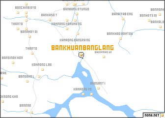
Ban Khuan Bang Lang (Yala, Thailand)Ban Khuan Bang Lang is a town in the Yala region of Thailand. An overview map of the region around Ban Khuan Bang Lang is displayed below.
regional and 3d topo map of Ban Khuan Bang Lang, Thailand ::
Ban Khuan Bang Lang airports ::
The nearest airport is NAW - Narathiwat, located 65.1 km north east of Ban Khuan Bang Lang.
Other airports nearby include PAN - Pattani (71.1 km north), AOR - Alor Setar Sultan Abdul Halim (97.9 km west), KBR - Kota Bahru Sultan Ismail Petra (111.9 km east), HDY - Songkhla Hat Yai Intl (130.6 km north west), Nearby towns ::
Kampong Bang Rang (3.6km north west) //
Ban Phak Di (4.8km east) //
Ban Bang Lang (5.9km north) //
Ban Kala Pho (6.4km north west) //
Ban Santi (7.5km south east) //
Kampong Karumang (7.7km north west) //
Kampong Yo (8.0km south) //
Ban Yo (8.0km south) //
Kampong Lamlu (8.2km south) //
Kampong Batungo (8.9km north) //
Ban Bathu Ngo (9.4km north) //
Ban Khao Nam Tok (9.8km north east) //
Ban Ka Sot (11.5km north west) //
[all distances 'as the bird flies' and approximate] 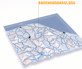 Places with similar names to Ban Khuan Bang Lang, Thailand :: Disclaimer :: Information on this page comes without warranty of any kind |
||
|
Where is Ban Khuan Bang Lang? Elevation and coordinates ::
Latitude (lat): 6°9'18"N Longitude (lon): 101°16'54"E
Elevation (approx.): 69m (map arrows pan, magnifying glasses zoom) |
||
|
Visiting Ban Khuan Bang Lang? Hotel/Accommodation ::
Book a hotel in Ban Khuan Bang Lang Travel Guide ::
Buy a travel guide for Thailand rental cars ::
car rental offers GPS waypoint ::
download a GPX waypoint (PoI) of Ban Khuan Bang Lang for your GPS receiver
|
||