|
search place name
|
||
Ban Ko Po (Trang, Thailand)Ban Ko Po is a town in the Trang region of Thailand. An overview map of the region around Ban Ko Po is displayed below.
regional and 3d topo map of Ban Ko Po, Thailand ::

Ban Ko Po airports ::
The nearest airport is TST - Trang, located 53.4 km east of Ban Ko Po.
Other airports nearby include HKT - Phuket Intl (110.5 km north west), NST - Nakhon Si Thammarat Cha Ian (137.7 km north east), LGK - Pulau Langkawi Intl (148.5 km south east), HDY - Songkhla Hat Yai Intl (154.1 km south east), Nearby towns ::
Ko Lanta (5.8km west) //
Ban Laem Sai (6.7km north east) //
Ban Khlong Hoi Khong (7.3km west) //
Ban Ru Yai (7.8km north west) //
Ban Thung Khok Phae (7.8km north west) //
[all distances 'as the bird flies' and approximate] 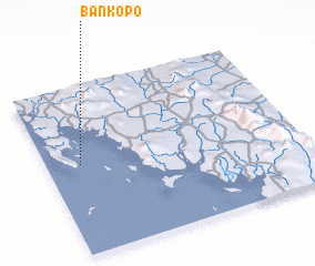 Places with similar names to Ban Ko Po, Thailand ::
// Bone Gap (US)
// Ban Kae Pe (TH)
// Ban Kapi (TH)
// Ban Kapo (TH)
// Ban Kapu (TH)
// Ban Kiap (TH)
// Ban Kip Pae (TH)
// Ban Ko Pao (TH)
// Ban Ko Po (TH)
// Ban Kup (TH)
Disclaimer :: Information on this page comes without warranty of any kind |
||
|
Where is Ban Ko Po? Elevation and coordinates ::
Latitude (lat): 7°32'0"N Longitude (lon): 99°8'0"E
Elevation (approx.): 24m (map arrows pan, magnifying glasses zoom) |
||
|
Visiting Ban Ko Po? Hotel/Accommodation ::
Book a hotel in Ban Ko Po Travel Guide ::
Buy a travel guide for Thailand rental cars ::
car rental offers GPS waypoint ::
download a GPX waypoint (PoI) of Ban Ko Po for your GPS receiver
|
||