|
search place name
|
||
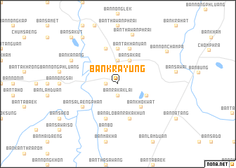
Ban Krayung (Surin, Thailand)Ban Krayung is a town in the Surin region of Thailand. An overview map of the region around Ban Krayung is displayed below.
regional and 3d topo map of Ban Krayung, Thailand ::
Ban Krayung airports ::
The nearest airport is NAK - Nakhon Ratchasima Khorat, located 151.8 km west of Ban Krayung.
Other airports nearby include REP - Siem-reap Siem Reap (186.6 km south), ZVK - Savannakhet (214.2 km north east), Nearby towns ::
Ban Khu (1.8km west) //
Ban Raka Klai (1.9km south) //
Ban Phia Ram (2.6km north west) //
Ban Khok Arok (3.7km north) //
Ban Sakae (4.1km north east) //
Ban Salaeng Phan (4.7km north east) //
Ban Khok Phra (4.8km south east) //
Ban Khok Wat (5.2km south east) //
Ban Sadao (5.6km north) //
Ban Tae (5.8km north) //
Ban Alo (5.8km south) //
Ban Ta Khanuan (5.8km north) //
Ban Raka Khun (5.8km south) //
Ban Salaeng Phan (6.5km south west) //
Ban Bo (7.6km south) //
Ban Thawan Phrai (8.1km north) //
Ban Kanang (8.1km north west) //
Ban Lum Din (9.2km north west) //
Ban Non Champa (9.1km north east) //
Ban Non Champa (10.3km north west) //
Ban Sa Kut (10.3km north west) //
[all distances 'as the bird flies' and approximate]  Places with similar names to Ban Krayung, Thailand :: Disclaimer :: Information on this page comes without warranty of any kind |
||
|
Where is Ban Krayung? Elevation and coordinates ::
Latitude (lat): 15°4'0"N Longitude (lon): 103°29'0"E
Elevation (approx.): 140m (map arrows pan, magnifying glasses zoom) |
||
|
Visiting Ban Krayung? Hotel/Accommodation ::
Book a hotel in Ban Krayung Travel Guide ::
Buy a travel guide for Thailand rental cars ::
car rental offers GPS waypoint ::
download a GPX waypoint (PoI) of Ban Krayung for your GPS receiver
|
||