|
search place name
|
||
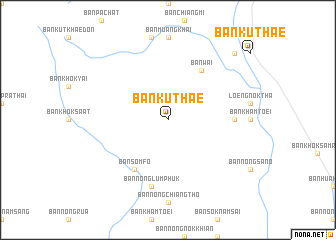
Ban Kut Hae (Thailand)Ban Kut Hae is a town in Thailand. An overview map of the region around Ban Kut Hae is displayed below.
regional and 3d topo map of Ban Kut Hae, Thailand ::
Ban Kut Hae airports ::
The nearest airport is ZVK - Savannakhet, located 54.0 km north east of Ban Kut Hae.
Other airports nearby include SNO - Sakon Nakhon (116.9 km north), PKZ - Pakse (185.5 km south east), UTH - Udon Thani (220.2 km north west), VTE - Vientiane Wattay Intl (282.0 km north west), Nearby towns ::
Ban Som Fo (6.6km south west) //
Ban Wai (6.6km north east) //
Ban Don Hi (7.1km east) //
Ban Nong Lum Phuk (7.6km south) //
Ban Kut Mahong (10.3km north east) //
[all distances 'as the bird flies' and approximate] 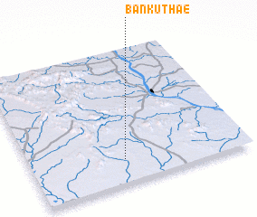 Places with similar names to Ban Kut Hae, Thailand ::
// Ban Kat Hao (TH)
// Ban Kathu (TH)
// Ban Ketha (TH)
// Ban Ket Ho (TH)
// Ban Ko Tha (TH)
// Ban Ko Tha (TH)
// Ban Ko Thai (TH)
// Ban Kut Hae (TH)
// Ban Kut Hae (TH)
// Ban Kut Hai (TH)
Disclaimer :: Information on this page comes without warranty of any kind |
||
|
Where is Ban Kut Hae? Elevation and coordinates ::
Latitude (lat): 16°11'0"N Longitude (lon): 104°26'0"E
Elevation (approx.): 202m (map arrows pan, magnifying glasses zoom) |
||
|
Visiting Ban Kut Hae? Hotel/Accommodation ::
Book a hotel in Ban Kut Hae Travel Guide ::
Buy a travel guide for Thailand rental cars ::
car rental offers GPS waypoint ::
download a GPX waypoint (PoI) of Ban Kut Hae for your GPS receiver
|
||