|
search place name
|
||
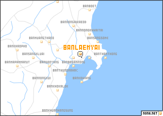
Ban Laem Yai (Chumphon, Thailand)Ban Laem Yai is a town in the Chumphon region of Thailand. An overview map of the region around Ban Laem Yai is displayed below.
regional and 3d topo map of Ban Laem Yai, Thailand ::
Ban Laem Yai airports ::
The nearest airport is MGZ - Myeik, located 195.3 km north west of Ban Laem Yai.
Other airports nearby include HHQ - Prachuap Khiri Khan Hua Hin (201.0 km north), UTP - Rayong U Taphao Intl (260.0 km north east), Nearby towns ::
Ban Tha Aet (1.8km east) //
Ban Bang Duan (1.8km west) //
Ban Tha Mat (1.8km west) //
Ban Bo Samrong (2.6km south west) //
Ban Sang Som (4) (5.2km north east) //
Ban Thung Maha (2) (5.2km south west) //
Ban Tham Thong (5.5km east) //
Ban Ko Wiang (5.6km south) //
Ban Nong Khwai Tai (5.9km north) //
Ban Don Taeng (5.8km west) //
Ban Don Yang (7.5km west) //
Ban Nong Ai Kaeo (1) (7.6km north) //
Ban Huai Rak Mai (8.2km north west) //
Ban Mai Liap (8.2km north west) //
Ban Kho Kalok (9.2km south west) //
[all distances 'as the bird flies' and approximate]  Places with similar names to Ban Laem Yai, Thailand ::
// Ban Laem Yai (TH)
// Ban Lom Yai (TH)
Disclaimer :: Information on this page comes without warranty of any kind |
||
|
Where is Ban Laem Yai? Elevation and coordinates ::
Latitude (lat): 10°53'0"N Longitude (lon): 99°28'0"E
Elevation (approx.): 32m (map arrows pan, magnifying glasses zoom) |
||
|
Visiting Ban Laem Yai? Hotel/Accommodation ::
Book a hotel in Ban Laem Yai Travel Guide ::
Buy a travel guide for Thailand rental cars ::
car rental offers GPS waypoint ::
download a GPX waypoint (PoI) of Ban Laem Yai for your GPS receiver
|
||