|
search place name
|
||
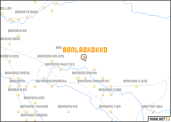
Ban Lao Kok Ko (Prachin Buri, Thailand)Ban Lao Kok Ko is a town in the Prachin Buri region of Thailand. An overview map of the region around Ban Lao Kok Ko is displayed below.
regional and 3d topo map of Ban Lao Kok Ko, Thailand ::
Ban Lao Kok Ko airports ::
The nearest airport is NAK - Nakhon Ratchasima Khorat, located 109.4 km north of Ban Lao Kok Ko.
Other airports nearby include BKK - Bangkok Intl (148.8 km west), UTP - Rayong U Taphao Intl (176.0 km south west), REP - Siem-reap Siem Reap (206.7 km east), Nearby towns ::
Ban Non Yang Ngam (2.6km south east) //
Ban Dong Bang (3.7km south) //
Ban Nong Panha (3.7km south) //
Ban Kaeng (4.1km south west) //
Ban Nong Na Nai (4.0km north west) //
Ban Dan Khok Sung (5.2km south east) //
Ban Nong Phuk Tao (5.7km west) //
Ban Nong Khon Kaen (5.8km south) //
Ban Nong Phlong (7.2km west) //
Ban Kut Nao (7.2km west) //
Ban Lao Oi (7.7km south east) //
Ban Sala Lamduan (8.2km south east) //
Ban Tha Chang (9.1km south west) //
Ban Tha Chang (9.1km south west) //
Sathani Ban Kaeng (9.1km south west) //
Ban Wang Chan (9.2km south east) //
[all distances 'as the bird flies' and approximate]  Places with similar names to Ban Lao Kok Ko, Thailand :: Disclaimer :: Information on this page comes without warranty of any kind |
||
|
Where is Ban Lao Kok Ko? Elevation and coordinates ::
Latitude (lat): 13°57'0"N Longitude (lon): 101°59'0"E
Elevation (approx.): 21m (map arrows pan, magnifying glasses zoom) |
||
|
Visiting Ban Lao Kok Ko? Hotel/Accommodation ::
Book a hotel in Ban Lao Kok Ko Travel Guide ::
Buy a travel guide for Thailand rental cars ::
car rental offers GPS waypoint ::
download a GPX waypoint (PoI) of Ban Lao Kok Ko for your GPS receiver
|
||