|
search place name
|
||
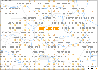
Ban Lao Tao (Nakhon Pathom, Thailand)Ban Lao Tao is a town in the Nakhon Pathom region of Thailand. An overview map of the region around Ban Lao Tao is displayed below.
regional and 3d topo map of Ban Lao Tao, Thailand ::
Ban Lao Tao airports ::
The nearest airport is BKK - Bangkok Intl, located 56.6 km east of Ban Lao Tao.
Other airports nearby include HHQ - Prachuap Khiri Khan Hua Hin (140.5 km south), UTP - Rayong U Taphao Intl (167.9 km south east), MGZ - Myeik (226.3 km south west), NAK - Nakhon Ratchasima Khorat (243.7 km north east), Nearby towns ::
Ban Phai Laem (0.0km north) //
Ban Nong O (1.8km west) //
Ban Ko Klang (1.8km east) //
Ban Don Klang (1.9km south) //
Ban Huai Phra (1.9km north) //
Ban Noi (1.9km north) //
Ban Dum Hak (2.6km south west) //
Ban Map Khae (2.6km south west) //
Ban Ya Phraek (2.6km north west) //
Ban Thung Phichai (2.6km north west) //
Ban Kong Lat (2.6km south east) //
Ban Huai Duan (2.6km south east) //
Ban Ta Kan (2.6km south east) //
Ban Uthai (3.7km south) //
Ban Phaniang Taek (3.7km south) //
Ban Sam Chaem (3.6km west) //
Ban Huai Chan (4.1km south west) //
Ban Dong Luak (4.1km south east) //
Ban Hua Na (4.1km south east) //
Ban Song Hong (4.0km north west) //
Ban Ta Kong (4.0km south west) //
Ban Phum (5.2km north west) //
Ban Thung Phao Tao (5.2km south west) //
Ban Hua Thanon (5.2km north east) //
Ban Sam Kaeo (5.6km north) //
Ban Chaeng Ngam (5.8km north) //
Ban Samnak Khlo (5.8km south) //
Ban Don Klang (5.8km north) //
Ban Suan Mai (5.8km south) //
[all distances 'as the bird flies' and approximate]  Places with similar names to Ban Lao Tao, Thailand ::
Disclaimer :: Information on this page comes without warranty of any kind |
||
|
Where is Ban Lao Tao? Elevation and coordinates ::
Latitude (lat): 13°54'0"N Longitude (lon): 100°5'0"E
Elevation (approx.): 7m (map arrows pan, magnifying glasses zoom) |
||
|
Visiting Ban Lao Tao? Hotel/Accommodation ::
Book a hotel in Ban Lao Tao Travel Guide ::
Buy a travel guide for Thailand rental cars ::
car rental offers GPS waypoint ::
download a GPX waypoint (PoI) of Ban Lao Tao for your GPS receiver
|
||