|
search place name
|
||
Ban Lin Thin (2) (Kanchanaburi, Thailand)Ban Lin Thin (2) is a town in the Kanchanaburi region of Thailand. An overview map of the region around Ban Lin Thin (2) is displayed below.
regional and 3d topo map of Ban Lin Thin (2), Thailand ::

Ban Lin Thin (2) airports ::
The nearest airport is BKK - Bangkok Intl, located 208.0 km east of Ban Lin Thin (2).
Other airports nearby include HHQ - Prachuap Khiri Khan Hua Hin (247.3 km south east), Nearby towns ::
Ban Nong Bang (3.6km east) //
Ban Phu Nam Ron (4.0km south west) //
Ban Na Makui (5.2km south west) //
Ban Phu Thong (5.4km west) //
Ban Gaeng Cho (5.6km south) //
Ban Kui Yae (5.7km west) //
Ban Wang Hin (1) (7.4km west) //
Ban Ni Khu Hu (8.1km north east) //
Ban Thung Na (8.2km south east) //
Ban Thung Na Roi Chang (8.2km south east) //
Ban Phlu Lo (8.1km south west) //
Ban Kui Mang (9.1km north west) //
[all distances 'as the bird flies' and approximate] 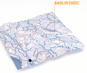 Places with similar names to Ban Lin Thin (2), Thailand ::
// Ban Lan Thong (TH)
// Ban Lian Thong (TH)
Disclaimer :: Information on this page comes without warranty of any kind |
||
|
Where is Ban Lin Thin (2)? Elevation and coordinates ::
Latitude (lat): 14°34'0"N Longitude (lon): 98°48'0"E
Elevation (approx.): 88m (map arrows pan, magnifying glasses zoom) |
||
|
Visiting Ban Lin Thin (2)? Hotel/Accommodation ::
Book a hotel in Ban Lin Thin (2) Travel Guide ::
Buy a travel guide for Thailand rental cars ::
car rental offers GPS waypoint ::
download a GPX waypoint (PoI) of Ban Lin Thin (2) for your GPS receiver
|
||