|
search place name
|
||
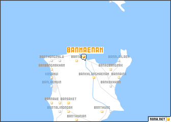
Ban Mae Nam (Surat Thani, Thailand)Ban Mae Nam is a town in the Surat Thani region of Thailand. An overview map of the region around Ban Mae Nam is displayed below.
regional and 3d topo map of Ban Mae Nam, Thailand ::
Ban Mae Nam airports ::
The nearest airport is NST - Nakhon Si Thammarat Cha Ian, located 121.3 km south of Ban Mae Nam.
Other airports nearby include HKT - Phuket Intl (245.2 km south west), Nearby towns ::
Ban Tai (1.8km west) //
Ban Khlong Mae Nam (4.1km south east) //
Ban Bang Po (5.5km west) //
Ban Ao Bang Rak (5.8km east) //
Ban Plai Laem (7.3km east) //
Ban Thong Phlu (7.3km west) //
Ban Bang Makham (7.5km west) //
Ban Ko Khwan (7.8km south east) //
Ban Nai Na (8.2km south east) //
Ko Samui (8.2km south west) //
Ban Laem Din (9.2km south west) //
[all distances 'as the bird flies' and approximate]  Places with similar names to Ban Mae Nam, Thailand ::
// Ban Mae Nam (TH)
// Ban Mae Nam (TH)
// Ban Maeo Nam Mao (TH)
// Ban Mon Mai (TH)
// Ban Mènam (LA)
// Bản Nam Nam (VN)
Disclaimer :: Information on this page comes without warranty of any kind |
||
|
Where is Ban Mae Nam? Elevation and coordinates ::
Latitude (lat): 9°34'0"N Longitude (lon): 100°0'0"E
Elevation (approx.): 14m (map arrows pan, magnifying glasses zoom) |
||
|
Visiting Ban Mae Nam? Hotel/Accommodation ::
Book a hotel in Ban Mae Nam Travel Guide ::
Buy a travel guide for Thailand rental cars ::
car rental offers GPS waypoint ::
download a GPX waypoint (PoI) of Ban Mae Nam for your GPS receiver
|
||