|
search place name
|
||
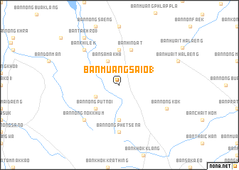
Ban Muang Sai O (1) (Buriram, Thailand)Ban Muang Sai O (1) is a town in the Buriram region of Thailand. An overview map of the region around Ban Muang Sai O (1) is displayed below.
regional and 3d topo map of Ban Muang Sai O (1), Thailand ::
Ban Muang Sai O (1) airports ::
The nearest airport is NAK - Nakhon Ratchasima Khorat, located 52.5 km west of Ban Muang Sai O (1).
Other airports nearby include REP - Siem-reap Siem Reap (217.0 km south east), BKK - Bangkok Intl (240.5 km south west), Nearby towns ::
Ban Sa Makha (4.1km north west) //
Ban Nong Sakae Khrua (4.0km south west) //
Ban Nong Put Noi (5.2km south west) //
Ban Nong Khrua (5.6km south) //
Amphoe Huai Thalaeng (5.6km south) //
Ban Hin Dat (5.6km north) //
Ban Hin Dat (5.8km north) //
Ban Nong Phet Sena (7.4km south) //
Ban Nong Nok Khum (7.7km south west) //
Ban Khi Lek (7.7km north west) //
Ban Nong Kok (8.1km south east) //
Ban Takhro (1) (9.2km north west) //
[all distances 'as the bird flies' and approximate] 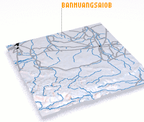 Places with similar names to Ban Muang Sai O (1), Thailand :: Disclaimer :: Information on this page comes without warranty of any kind |
||
|
Where is Ban Muang Sai O (1)? Elevation and coordinates ::
Latitude (lat): 14°57'0"N Longitude (lon): 102°34'0"E
Elevation (approx.): 208m (map arrows pan, magnifying glasses zoom) |
||
|
Visiting Ban Muang Sai O (1)? Hotel/Accommodation ::
Book a hotel in Ban Muang Sai O (1) Travel Guide ::
Buy a travel guide for Thailand rental cars ::
car rental offers GPS waypoint ::
download a GPX waypoint (PoI) of Ban Muang Sai O (1) for your GPS receiver
|
||