|
search place name
|
||
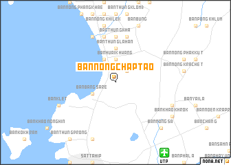
Ban Nong Chap Tao (Chon Buri, Thailand)Ban Nong Chap Tao is a town in the Chon Buri region of Thailand. An overview map of the region around Ban Nong Chap Tao is displayed below.
regional and 3d topo map of Ban Nong Chap Tao, Thailand ::
Ban Nong Chap Tao airports ::
The nearest airport is UTP - Rayong U Taphao Intl, located 13.8 km south east of Ban Nong Chap Tao.
Other airports nearby include HHQ - Prachuap Khiri Khan Hua Hin (107.9 km west), BKK - Bangkok Intl (129.8 km north), Nearby towns ::
Ban Map Fakthong (2.6km north east) //
Ban Huai Khwang (3.7km north) //
Ban Bang Sare (4.1km south west) //
Ban Amphoe (4.1km north west) //
Ban Thung Lahan (5.6km north) //
Ban Thung Kha (7.4km north) //
Ban Nam Mao (7.6km north) //
Ban Na Chom Thian (7.6km north) //
Ban Huai Yai (7.6km north) //
Ban Pak Khlong (8.2km north west) //
Ban Nong Sa (10.4km south east) //
[all distances 'as the bird flies' and approximate]  Places with similar names to Ban Nong Chap Tao, Thailand :: Disclaimer :: Information on this page comes without warranty of any kind |
||
|
Where is Ban Nong Chap Tao? Elevation and coordinates ::
Latitude (lat): 12°47'0"N Longitude (lon): 100°56'0"E
Elevation (approx.): 31m (map arrows pan, magnifying glasses zoom) |
||
|
Visiting Ban Nong Chap Tao? Hotel/Accommodation ::
Book a hotel in Ban Nong Chap Tao Travel Guide ::
Buy a travel guide for Thailand rental cars ::
car rental offers GPS waypoint ::
download a GPX waypoint (PoI) of Ban Nong Chap Tao for your GPS receiver
|
||