|
search place name
|
||
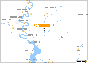
Ban Nong Pu (1) (Chiang Mai, Thailand)Ban Nong Pu (1) is a town in the Chiang Mai region of Thailand. An overview map of the region around Ban Nong Pu (1) is displayed below.
regional and 3d topo map of Ban Nong Pu (1), Thailand ::
Ban Nong Pu (1) airports ::
The nearest airport is LPT - Lampang, located 90.7 km east of Ban Nong Pu (1).
Other airports nearby include PRH - Phrae (157.2 km east), PHS - Phitsanulok (218.9 km south east), Nearby towns ::
Ban Huai Bong (1.0km south west) //
Ban Pa Thop Tai (1.6km north) //
Ban Lao Manao (3.2km south) //
Ban Mae Yui (3.6km north east) //
Ban Thong (5.2km south west) //
Ban Dong Than (5.9km west) //
Ban Tha Dua (6.6km south west) //
Ban Tan Tai (6.9km north) //
Ban Yang (7.1km south east) //
Ban Tan Nua (7.6km north) //
Ban Noi (7.5km south west) //
Ban Aen (8.1km west) //
Ban Dong Dam (9.1km north west) //
Ban Wang Mo (8.9km north west) //
[all distances 'as the bird flies' and approximate] 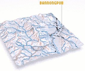 Places with similar names to Ban Nong Pu (1), Thailand :: Disclaimer :: Information on this page comes without warranty of any kind |
||
|
Where is Ban Nong Pu (1)? Elevation and coordinates ::
Latitude (lat): 18°2'0"N Longitude (lon): 98°41'0"E
Elevation (approx.): 284m (map arrows pan, magnifying glasses zoom) |
||
|
Visiting Ban Nong Pu (1)? Hotel/Accommodation ::
Book a hotel in Ban Nong Pu (1) Travel Guide ::
Buy a travel guide for Thailand rental cars ::
car rental offers GPS waypoint ::
download a GPX waypoint (PoI) of Ban Nong Pu (1) for your GPS receiver
|
||