|
search place name
|
||
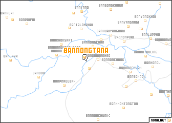
Ban Nong Ta Na (Chaiyaphum, Thailand)Ban Nong Ta Na is a town in the Chaiyaphum region of Thailand. An overview map of the region around Ban Nong Ta Na is displayed below.
regional and 3d topo map of Ban Nong Ta Na, Thailand ::
Ban Nong Ta Na airports ::
The nearest airport is NAK - Nakhon Ratchasima Khorat, located 96.9 km south of Ban Nong Ta Na.
Other airports nearby include LOE - Loei (187.3 km north), PHS - Phitsanulok (194.0 km north west), UTH - Udon Thani (213.0 km north east), BKK - Bangkok Intl (237.0 km south west), Nearby towns ::
Ban Huai Raheo Noi (1.7km south east) //
Nong Buaraheo (2.5km east) //
Ban Nong Bua (3.3km north east) //
Ban Nong Chan (3.6km north east) //
Ban Wang Kamphaeng (5.1km north west) //
Ban Lahan Khai (5.7km north east) //
Ban Non Chuak (5.7km east) //
Ban Noi (6.3km west) //
Ban Khok Sa-at (6.4km north west) //
Ban Pradu Bak (7.0km south west) //
Ban Talom Phai (7.1km north) //
Ban Huai Yang Na Di (7.7km north east) //
Ban Huai Rai (8.1km north west) //
Ban Non Puai (9.1km north east) //
Ban Nong Muang (10.1km south east) //
[all distances 'as the bird flies' and approximate]  Places with similar names to Ban Nong Ta Na, Thailand ::
// Binongtoan (PH)
// Binungto-an (PH)
// Bennington (US)
// Bennington (US)
// Bennington (US)
// Bennington (US)
// Ban Nong Daen (TH)
// Ban Nong Dan (TH)
// Ban Nong Dan (TH)
// Ban Nong Dan (TH)
Disclaimer :: Information on this page comes without warranty of any kind |
||
|
Where is Ban Nong Ta Na? Elevation and coordinates ::
Latitude (lat): 15°44'49"N Longitude (lon): 101°44'35"E
Elevation (approx.): 217m (map arrows pan, magnifying glasses zoom) |
||
|
Visiting Ban Nong Ta Na? Hotel/Accommodation ::
Book a hotel in Ban Nong Ta Na Travel Guide ::
Buy a travel guide for Thailand rental cars ::
car rental offers GPS waypoint ::
download a GPX waypoint (PoI) of Ban Nong Ta Na for your GPS receiver
|
||