|
search place name
|
||
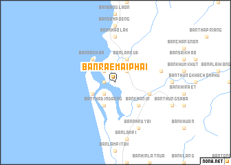
Ban Rae Mai Phai (Phangnga, Thailand)Ban Rae Mai Phai is a town in the Phangnga region of Thailand. An overview map of the region around Ban Rae Mai Phai is displayed below.
regional and 3d topo map of Ban Rae Mai Phai, Thailand ::
Ban Rae Mai Phai airports ::
The nearest airport is HKT - Phuket Intl, located 48.9 km south of Ban Rae Mai Phai.
Other airports nearby include NST - Nakhon Si Thammarat Cha Ian (188.0 km east), TST - Trang (189.6 km south east), Nearby towns ::
Ban Thap Mo (1.8km west) //
Ban Laem Po (2.6km north west) //
Ban Laem Ma (2.6km south west) //
Ban Lam Kaen (2.6km north east) //
Ban Thap Lamu (2.6km north west) //
Ban Khao Tam Chuak (4.1km south west) //
Ban Lam Ru (1) (4.1km north east) //
Ban Tha Din Daeng (4.1km south west) //
Ban Ao Kham (5.2km north west) //
Ban Khanim (5.2km south east) //
Ban Thung Maphrao (5.8km east) //
Ban Khao Lak (7.4km north) //
Ban Lam Phli (7.6km east) //
Ban Phru Yai (8.3km south east) //
[all distances 'as the bird flies' and approximate]  Places with similar names to Ban Rae Mai Phai, Thailand ::
// Ban Rom Pho (TH)
Disclaimer :: Information on this page comes without warranty of any kind |
||
|
Where is Ban Rae Mai Phai? Elevation and coordinates ::
Latitude (lat): 8°33'0"N Longitude (lon): 98°15'0"E
Elevation (approx.): 10m (map arrows pan, magnifying glasses zoom) |
||
|
Visiting Ban Rae Mai Phai? Hotel/Accommodation ::
Book a hotel in Ban Rae Mai Phai Travel Guide ::
Buy a travel guide for Thailand rental cars ::
car rental offers GPS waypoint ::
download a GPX waypoint (PoI) of Ban Rae Mai Phai for your GPS receiver
|
||