|
search place name
|
||
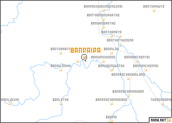
Ban Rai Pa (Kanchanaburi, Thailand)Ban Rai Pa is a town in the Kanchanaburi region of Thailand. An overview map of the region around Ban Rai Pa is displayed below.
regional and 3d topo map of Ban Rai Pa, Thailand ::
Ban Rai Pa airports ::
The nearest airport is PHS - Phitsanulok, located 290.4 km north east of Ban Rai Pa.
Nearby towns ::
Ban Le The (1.8km west) //
Ban Don Khrong (3.6km east) //
Ban Pak Huai Kroeng Krai (5.7km west) //
Ban Pilok (5.7km east) //
Ban Tha Mayo (5.7km west) //
Ban Kaeng Katok (5.7km east) //
Ban Pilok Khi (5.7km west) //
Ban Tha Mayo (7.7km north east) //
Ban Wang Patho (8.2km north east) //
Ban Tha Thung Na (8.1km north east) //
Ban Tha Madua (9.1km north east) //
[all distances 'as the bird flies' and approximate]  Places with similar names to Ban Rai Pa, Thailand ::
// Ban Rai Pa (TH)
// Ban Rai Pa (TH)
// Ban Rai Pa (TH)
// Ban Rai Pae (TH)
// Ban Ru Po (TH)
// Ban Rapo (LA)
// Bannerup (DK)
// Bønnerup (DK)
// Bänarp (SE)
// Bänarp (SE)
Disclaimer :: Information on this page comes without warranty of any kind |
||
|
Where is Ban Rai Pa? Elevation and coordinates ::
Latitude (lat): 14°49'0"N Longitude (lon): 98°29'0"E
Elevation (approx.): 153m (map arrows pan, magnifying glasses zoom) |
||
|
Visiting Ban Rai Pa? Hotel/Accommodation ::
Book a hotel in Ban Rai Pa Travel Guide ::
Buy a travel guide for Thailand rental cars ::
car rental offers GPS waypoint ::
download a GPX waypoint (PoI) of Ban Rai Pa for your GPS receiver
|
||