|
search place name
|
||
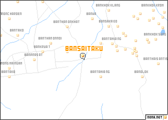
Ban Sai Taku (Buriram, Thailand)Ban Sai Taku is a town in the Buriram region of Thailand. An overview map of the region around Ban Sai Taku is displayed below.
regional and 3d topo map of Ban Sai Taku, Thailand ::
Ban Sai Taku airports ::
The nearest airport is REP - Siem-reap Siem Reap, located 127.9 km south east of Ban Sai Taku.
Other airports nearby include NAK - Nakhon Ratchasima Khorat (134.5 km north west), Nearby towns ::
Ban Lahok Tabaeng (4.0km north west) //
Ban Pling (5.2km north east) //
Ban Ta Miang (5.2km south east) //
Ban Ta Miang (7.1km north east) //
Ban Nong Chup (7.4km east) //
Ban Phun Suk (7.6km north east) //
Ban Thanon Noi (8.1km north west) //
Ban Thanon Khat (8.2km north west) //
Ban Sa Kaeo (9.2km north east) //
Ban La-O (10.4km north east) //
Ban Nong Khaen (10.5km north east) //
[all distances 'as the bird flies' and approximate] 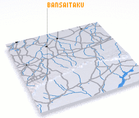 Places with similar names to Ban Sai Taku, Thailand ::
// Ban Sa Tak (TH)
// Ban Sa Tako (TH)
// Ban Sa Tako (TH)
// Baños de Agua (CU)
// Banzetaka (CD)
// Banssédougou (GN)
// Banssédougou (GN)
// Bản Suối Duc (VN)
// Banasédougou (CI)
Disclaimer :: Information on this page comes without warranty of any kind |
||
|
Where is Ban Sai Taku? Elevation and coordinates ::
Latitude (lat): 14°24'0"N Longitude (lon): 103°12'0"E
Elevation (approx.): 198m (map arrows pan, magnifying glasses zoom) |
||
|
Visiting Ban Sai Taku? Hotel/Accommodation ::
Book a hotel in Ban Sai Taku Travel Guide ::
Buy a travel guide for Thailand rental cars ::
car rental offers GPS waypoint ::
download a GPX waypoint (PoI) of Ban Sai Taku for your GPS receiver
|
||