|
search place name
|
||
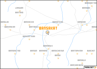
Ban Sakat (Surin, Thailand)Ban Sakat is a town in the Surin region of Thailand. An overview map of the region around Ban Sakat is displayed below.
regional and 3d topo map of Ban Sakat, Thailand ::
Ban Sakat airports ::
The nearest airport is REP - Siem-reap Siem Reap, located 133.6 km south of Ban Sakat.
Other airports nearby include NAK - Nakhon Ratchasima Khorat (183.3 km west), ZVK - Savannakhet (240.4 km north east), Nearby towns ::
Ban Satung (5.2km north east) //
Ban Ranuk (5.6km south) //
Ban Yaeng (5.7km west) //
Ban Krathiam (7.4km west) //
Ban Mano (7.6km south) //
Ban Phumikhadi (8.2km south east) //
Amphoe Sangkha (8.2km south east) //
Ban Sangkha (8.2km south east) //
Ban Si Charun (8.2km south east) //
Ban Kachai (8.1km north west) //
Ban Chok (8.1km north west) //
Ban Son (9.2km south west) //
Ban Na To (9.2km south west) //
Ban Mai (9.2km south west) //
[all distances 'as the bird flies' and approximate]  Places with similar names to Ban Sakat, Thailand ::
// Binscheid (DE)
// Ban Sakat (TH)
// Ban Sakat Tai (TH)
// Ban Sakat Tai (TH)
// Ban Sa Ket (TH)
// Ban Sa Ket (TH)
// Ban Sa Kut (TH)
// Ban Sa Kut (TH)
// Ban Sakut (TH)
// Ban Sok Dua (TH)
Disclaimer :: Information on this page comes without warranty of any kind |
||
|
Where is Ban Sakat? Elevation and coordinates ::
Latitude (lat): 14°37'0"N Longitude (lon): 103°45'0"E
Elevation (approx.): 169m (map arrows pan, magnifying glasses zoom) |
||
|
Visiting Ban Sakat? Hotel/Accommodation ::
Book a hotel in Ban Sakat Travel Guide ::
Buy a travel guide for Thailand rental cars ::
car rental offers GPS waypoint ::
download a GPX waypoint (PoI) of Ban Sakat for your GPS receiver
|
||