|
search place name
|
||
Ban Sam Krai (1) (Chumphon, Thailand)Ban Sam Krai (1) is a town in the Chumphon region of Thailand. An overview map of the region around Ban Sam Krai (1) is displayed below.
regional and 3d topo map of Ban Sam Krai (1), Thailand ::

Ban Sam Krai (1) airports ::
The nearest airport is MGZ - Myeik, located 198.5 km north of Ban Sam Krai (1).
Other airports nearby include HHQ - Prachuap Khiri Khan Hua Hin (226.5 km north), UTP - Rayong U Taphao Intl (292.9 km north east), Nearby towns ::
Ban Wang Maprang (1) (1.9km south) //
Ban Na Yao (1) (1.9km north) //
Ban Khot Sok (2.6km north west) //
Ban Na Muang (3.7km south) //
Ban Khuring (3.7km south) //
Ban Lan Tao (3.7km south) //
Ban Salui (1) (3.7km north) //
Ban Na Lum (5.6km south) //
Ban Na Phru (5.6km south) //
Ban Ta Hong (2) (5.6km north) //
Ban Nong Pla (5.9km south) //
Ban Na Wan (5.9km south) //
Ban Nong Kok (6.6km south east) //
Ban Khlong Thong Lang (6.6km south east) //
Ban Na Sang (7.6km south) //
Tha Sae (7.6km south) //
Ban Thale Sap (7.5km east) //
[all distances 'as the bird flies' and approximate] 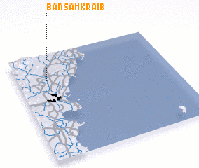 Places with similar names to Ban Sam Krai (1), Thailand :: Disclaimer :: Information on this page comes without warranty of any kind |
||
|
Where is Ban Sam Krai (1)? Elevation and coordinates ::
Latitude (lat): 10°44'0"N Longitude (lon): 99°11'0"E
Elevation (approx.): 30m (map arrows pan, magnifying glasses zoom) |
||
|
Visiting Ban Sam Krai (1)? Hotel/Accommodation ::
Book a hotel in Ban Sam Krai (1) Travel Guide ::
Buy a travel guide for Thailand rental cars ::
car rental offers GPS waypoint ::
download a GPX waypoint (PoI) of Ban Sam Krai (1) for your GPS receiver
|
||