|
search place name
|
||
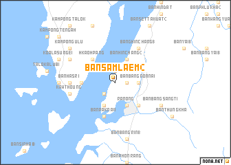
Ban Sam Laem (2) (Ranong, Thailand)Ban Sam Laem (2) is a town in the Ranong region of Thailand. An overview map of the region around Ban Sam Laem (2) is displayed below.
regional and 3d topo map of Ban Sam Laem (2), Thailand ::
Ban Sam Laem (2) airports ::
The nearest airport is HKT - Phuket Intl, located 211.3 km south of Ban Sam Laem (2).
Other airports nearby include NST - Nakhon Si Thammarat Cha Ian (224.1 km south east), Nearby towns ::
Ban Khao Lan (2) (1.8km east) //
Ban Sam Laem (1.9km north) //
Ban Sam Laem (2.6km south west) //
Ban Bang Non Nai (3.7km east) //
Ban Bang Non Nai (5) (3.7km east) //
Ranong (4.1km south east) //
Ban Hin Chang (2) (4.1km north east) //
Ban Khon Tham Rai (4.1km south west) //
Ban Lum Than (5.2km south east) //
Hkaohpang (5.2km north west) //
Pakklōhng (5.2km north west) //
Tanjong Gaja (5.5km west) //
Ban Pak Nam (5.9km south) //
Bang Hin Chang (1) (6.7km north east) //
Banhasri (7.3km west) //
Kawthoung (7.5km west) //
Ban Bang Sang Ti (8.2km south east) //
Kampong Lama (8.2km north west) //
Kampong Ulu (9.2km north west) //
[all distances 'as the bird flies' and approximate] 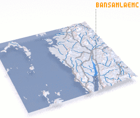 Places with similar names to Ban Sam Laem (2), Thailand :: Disclaimer :: Information on this page comes without warranty of any kind |
||
|
Where is Ban Sam Laem (2)? Elevation and coordinates ::
Latitude (lat): 10°0'0"N Longitude (lon): 98°37'0"E
Elevation (approx.): 183m (map arrows pan, magnifying glasses zoom) |
||
|
Visiting Ban Sam Laem (2)? Hotel/Accommodation ::
Book a hotel in Ban Sam Laem (2) Travel Guide ::
Buy a travel guide for Thailand rental cars ::
car rental offers GPS waypoint ::
download a GPX waypoint (PoI) of Ban Sam Laem (2) for your GPS receiver
|
||