|
search place name
|
||
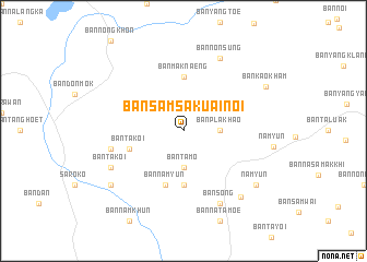
Ban Sam Sakuai Noi (Ubon Ratchathani, Thailand)Ban Sam Sakuai Noi is a town in the Ubon Ratchathani region of Thailand. An overview map of the region around Ban Sam Sakuai Noi is displayed below.
regional and 3d topo map of Ban Sam Sakuai Noi, Thailand ::
Ban Sam Sakuai Noi airports ::
The nearest airport is PKZ - Pakse, located 110.3 km north east of Ban Sam Sakuai Noi.
Other airports nearby include REP - Siem-reap Siem Reap (176.0 km south west), Nearby towns ::
Ban Pla Khao (3.6km east) //
Ban Kham (3.6km east) //
Ban Ta Mo (3.7km south) //
Ban Maknaeng (5.6km north) //
Ban Kho (5.6km south) //
Ban Ta Koi (5.7km west) //
Ban Nam Yun (5.8km south) //
Ban Nam Yun (5.8km south) //
Ban Nong Thap (5.9km north east) //
Ban Ta Kao (7.4km west) //
Ban Non Sung (8.2km north east) //
Ban Song (8.2km south east) //
Ban Ta Koi (8.1km south west) //
Ban Si Muang Mai (8.7km south east) //
Nam Yun (9.1km south east) //
Ban Romduan (9.1km south west) //
Ban Kao Kham (9.3km north east) //
[all distances 'as the bird flies' and approximate] 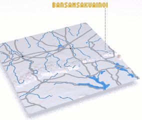 Places with similar names to Ban Sam Sakuai Noi, Thailand ::
// Ban Samsao Gnai (LA)
// Ban Samsok Noy (LA)
Disclaimer :: Information on this page comes without warranty of any kind |
||
|
Where is Ban Sam Sakuai Noi? Elevation and coordinates ::
Latitude (lat): 14°33'0"N Longitude (lon): 104°57'0"E
Elevation (approx.): 172m (map arrows pan, magnifying glasses zoom) |
||
|
Visiting Ban Sam Sakuai Noi? Hotel/Accommodation ::
Book a hotel in Ban Sam Sakuai Noi Travel Guide ::
Buy a travel guide for Thailand rental cars ::
car rental offers GPS waypoint ::
download a GPX waypoint (PoI) of Ban Sam Sakuai Noi for your GPS receiver
|
||