|
search place name
|
||
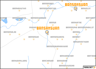
Ban Sam Suan (Thailand)Ban Sam Suan is a town in Thailand. An overview map of the region around Ban Sam Suan is displayed below.
regional and 3d topo map of Ban Sam Suan, Thailand ::
Ban Sam Suan airports ::
The nearest airport is LOE - Loei, located 130.2 km north of Ban Sam Suan.
Other airports nearby include UTH - Udon Thani (131.6 km north east), NAK - Nakhon Ratchasima Khorat (157.0 km south), VTE - Vientiane Wattay Intl (185.8 km north), PHS - Phitsanulok (208.8 km west), Nearby towns ::
Ban Kut Yom (0.0km north) //
Ban Rua (4.1km north east) //
Ban Nong Waeng (4.0km south east) //
Phu Khieo (5.6km west) //
Ban Nong Wa (5.6km west) //
Ban Nong Ngu Luam (5.6km east) //
Ban Nong Siang Sa (6.6km north west) //
Ban Nong Bua Phak Kwian (6.6km south east) //
Ban Nong Din Dam (9.0km north west) //
[all distances 'as the bird flies' and approximate] 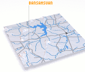 Places with similar names to Ban Sam Suan, Thailand ::
// Ban Samae San (TH)
// Ban Samae San (TH)
// Ban Sam Sen (TH)
// Ban Sam Suan (TH)
// Ban Samsao Noy (LA)
// Ban Sam Sun (LA)
Disclaimer :: Information on this page comes without warranty of any kind |
||
|
Where is Ban Sam Suan? Elevation and coordinates ::
Latitude (lat): 16°21'0"N Longitude (lon): 102°11'0"E
Elevation (approx.): 213m (map arrows pan, magnifying glasses zoom) |
||
|
Visiting Ban Sam Suan? Hotel/Accommodation ::
Book a hotel in Ban Sam Suan Travel Guide ::
Buy a travel guide for Thailand rental cars ::
car rental offers GPS waypoint ::
download a GPX waypoint (PoI) of Ban Sam Suan for your GPS receiver
|
||