|
search place name
|
||
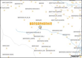
Ban Saphan Hin (Chai Nat, Thailand)Ban Saphan Hin is a town in the Chai Nat region of Thailand. An overview map of the region around Ban Saphan Hin is displayed below.
regional and 3d topo map of Ban Saphan Hin, Thailand ::
Ban Saphan Hin airports ::
The nearest airport is BKK - Bangkok Intl, located 164.3 km south east of Ban Saphan Hin.
Other airports nearby include PHS - Phitsanulok (180.3 km north), Nearby towns ::
Ban Don (3.1km north) //
Ban Nong Phai Kaen (4.1km south west) //
Ban Nong Katha (4.2km west) //
Ban Nong Sali (4.6km south) //
Ban Tha Kham (1) (5.3km south east) //
Ban Nong Sa (5.7km south east) //
Ban Nong Sano (6.7km south) //
Ban Nong Luang (7.6km south west) //
Ban Wang Man (7.6km east) //
Ban Nong Pla Ra (1) (8.2km north east) //
Ban Nong Mamong (8.3km north) //
Ban Thung Kwang (8.1km east) //
Ban Nong Pla Lai (8.5km north west) //
Ban Wang Nam Khao (8.9km north west) //
Ban Thung Samo (1) (9.4km north east) //
Ban Kut Chok (1) (10.8km north east) //
[all distances 'as the bird flies' and approximate] 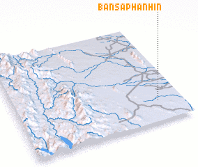 Places with similar names to Ban Saphan Hin, Thailand ::
// Ban Saphan Hin (TH)
// Ban Saphan Hin (TH)
// Ban Saphan Hin (TH)
// Ban Saphan Hin (TH)
// Ban Saphan Hin (TH)
// Ban Saphan Hin (TH)
// Ban Saphan Hin (TH)
Disclaimer :: Information on this page comes without warranty of any kind |
||
|
Where is Ban Saphan Hin? Elevation and coordinates ::
Latitude (lat): 15°12'19"N Longitude (lon): 99°51'23"E
Elevation (approx.): 50m (map arrows pan, magnifying glasses zoom) |
||
|
Visiting Ban Saphan Hin? Hotel/Accommodation ::
Book a hotel in Ban Saphan Hin Travel Guide ::
Buy a travel guide for Thailand rental cars ::
car rental offers GPS waypoint ::
download a GPX waypoint (PoI) of Ban Saphan Hin for your GPS receiver
|
||