|
search place name
|
||
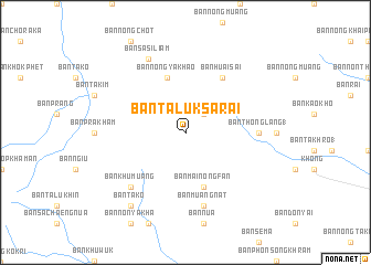
Ban Taluk Sarai (Nakhon Ratchasima, Thailand)Ban Taluk Sarai is a town in the Nakhon Ratchasima region of Thailand. An overview map of the region around Ban Taluk Sarai is displayed below.
regional and 3d topo map of Ban Taluk Sarai, Thailand ::
Ban Taluk Sarai airports ::
The nearest airport is NAK - Nakhon Ratchasima Khorat, located 60.7 km south of Ban Taluk Sarai.
Other airports nearby include UTH - Udon Thani (221.0 km north), LOE - Loei (224.6 km north), BKK - Bangkok Intl (244.2 km south west), PHS - Phitsanulok (253.3 km north west), Nearby towns ::
Ban Non Teng (2.6km north east) //
Ban Hin Tang (5.8km south) //
Ban Mai Nong Fan (5.8km south) //
Ban Nong Ya Khao (5.8km north) //
Ban Huai Sai (6.6km north east) //
Ban Thong Lang (1) (7.1km east) //
Ban Muang Nat (7.6km south) //
Ban Khu Muang (7.7km south west) //
Ban Sa Si Liam (8.2km north west) //
Ban Tako (9.1km south west) //
[all distances 'as the bird flies' and approximate] 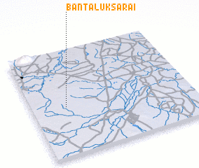 Places with similar names to Ban Taluk Sarai, Thailand :: Disclaimer :: Information on this page comes without warranty of any kind |
||
|
Where is Ban Taluk Sarai? Elevation and coordinates ::
Latitude (lat): 15°28'0"N Longitude (lon): 102°13'0"E
Elevation (approx.): 212m (map arrows pan, magnifying glasses zoom) |
||
|
Visiting Ban Taluk Sarai? Hotel/Accommodation ::
Book a hotel in Ban Taluk Sarai Travel Guide ::
Buy a travel guide for Thailand rental cars ::
car rental offers GPS waypoint ::
download a GPX waypoint (PoI) of Ban Taluk Sarai for your GPS receiver
|
||