|
search place name
|
||
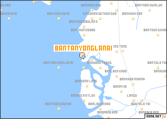
Ban Tanyong La Nai (Satun, Thailand)Ban Tanyong La Nai is a town in the Satun region of Thailand. An overview map of the region around Ban Tanyong La Nai is displayed below.
regional and 3d topo map of Ban Tanyong La Nai, Thailand ::
Ban Tanyong La Nai airports ::
The nearest airport is TST - Trang, located 60.4 km north of Ban Tanyong La Nai.
Other airports nearby include LGK - Pulau Langkawi Intl (70.6 km south), HDY - Songkhla Hat Yai Intl (78.5 km east), AOR - Alor Setar Sultan Abdul Halim (116.8 km south east), PAN - Pattani (163.7 km east), Nearby towns ::
Ban Buyoi (1.9km south) //
Ban Thung Muso (1.8km east) //
Ban Wang Thong (4.1km south east) //
Ban Khon Khlan (5.6km north) //
Ban Thung Sa Bo (5.6km north) //
Ban Tankong La Nai (5.8km west) //
Ban Son Klang (6.0km south) //
Ban Thung Bu Lang (7.4km north) //
Ban Wang Tong (7.6km east) //
Ban Laem Khae (8.2km south east) //
Ban Thung (8.9km east) //
Ban Pi Yai (11.1km south east) //
[all distances 'as the bird flies' and approximate] 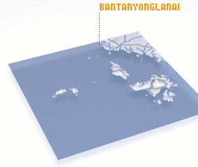 Places with similar names to Ban Tanyong La Nai, Thailand :: Disclaimer :: Information on this page comes without warranty of any kind |
||
|
Where is Ban Tanyong La Nai? Elevation and coordinates ::
Latitude (lat): 6°58'0"N Longitude (lon): 99°41'0"E
Elevation (approx.): -32768m (map arrows pan, magnifying glasses zoom) |
||
|
Visiting Ban Tanyong La Nai? Hotel/Accommodation ::
Book a hotel in Ban Tanyong La Nai Travel Guide ::
Buy a travel guide for Thailand rental cars ::
car rental offers GPS waypoint ::
download a GPX waypoint (PoI) of Ban Tanyong La Nai for your GPS receiver
|
||