|
search place name
|
||
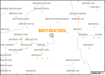
Ban Ta Pa Tong (Nan, Thailand)Ban Ta Pa Tong is a town in the Nan region of Thailand. An overview map of the region around Ban Ta Pa Tong is displayed below.
regional and 3d topo map of Ban Ta Pa Tong, Thailand ::
Ban Ta Pa Tong airports ::
The nearest airport is LPQ - Luang Prabang Luang Phabang Intl, located 131.4 km north east of Ban Ta Pa Tong.
Other airports nearby include PRH - Phrae (159.7 km south west), THL - Tachilek Tachileik (181.7 km north west), LPT - Lampang (201.1 km south west), VTE - Vientiane Wattay Intl (209.4 km south east), Nearby towns ::
Ban Chun (2.5km south west) //
Ban Toei (5.1km south west) //
Ban Nam Chun (5.6km east) //
Ban Khun Nam Ngaeng Noi (5.8km north) //
Ban Toei Klang (6.6km south west) //
Ban Na Lae (7.6km south) //
Ban Chun Tai (7.2km west) //
Ban Nam Yo (8.2km south west) //
Ban Pu Puk (9.1km south west) //
Ban Charaeng (9.1km south west) //
Ban Chalaeng (9.1km south west) //
[all distances 'as the bird flies' and approximate]  Places with similar names to Ban Ta Pa Tong, Thailand ::
// Bản Ðap Tong (VN)
Disclaimer :: Information on this page comes without warranty of any kind |
||
|
Where is Ban Ta Pa Tong? Elevation and coordinates ::
Latitude (lat): 19°16'0"N Longitude (lon): 101°6'0"E
Elevation (approx.): 795m (map arrows pan, magnifying glasses zoom) |
||
|
Visiting Ban Ta Pa Tong? Hotel/Accommodation ::
Book a hotel in Ban Ta Pa Tong Travel Guide ::
Buy a travel guide for Thailand rental cars ::
car rental offers GPS waypoint ::
download a GPX waypoint (PoI) of Ban Ta Pa Tong for your GPS receiver
|
||