|
search place name
|
||
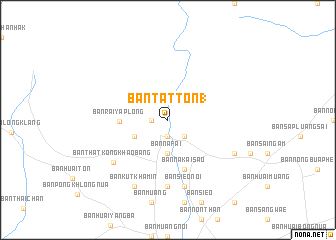
Ban Tat Ton (1) (Chaiyaphum, Thailand)Ban Tat Ton (1) is a town in the Chaiyaphum region of Thailand. An overview map of the region around Ban Tat Ton (1) is displayed below.
regional and 3d topo map of Ban Tat Ton (1), Thailand ::
Ban Tat Ton (1) airports ::
The nearest airport is NAK - Nakhon Ratchasima Khorat, located 112.5 km south of Ban Tat Ton (1).
Other airports nearby include LOE - Loei (168.1 km north), UTH - Udon Thani (178.2 km north east), PHS - Phitsanulok (208.9 km north west), Nearby towns ::
Ban Khro (1.8km west) //
Ban Huai Chan (1.9km south) //
Ban Na Si Nuan (2.6km south east) //
Ban Na Fai (3.7km south) //
Ban Nong Ya Plong (4.0km south west) //
Ban Rai Ya Plong (5.2km west) //
Ban Na Kai Sao (5.8km south) //
Ban Nong Waeng Noi (7.4km south) //
Ban Sieo Noi (7.6km south) //
Ban That Kong Khao Bang (7.5km south west) //
Ban Kut Khamin (8.2km south west) //
Ban Na Wang (8.0km south east) //
[all distances 'as the bird flies' and approximate] 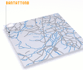 Places with similar names to Ban Tat Ton (1), Thailand :: Disclaimer :: Information on this page comes without warranty of any kind |
||
|
Where is Ban Tat Ton (1)? Elevation and coordinates ::
Latitude (lat): 15°57'0"N Longitude (lon): 102°2'0"E
Elevation (approx.): 199m (map arrows pan, magnifying glasses zoom) |
||
|
Visiting Ban Tat Ton (1)? Hotel/Accommodation ::
Book a hotel in Ban Tat Ton (1) Travel Guide ::
Buy a travel guide for Thailand rental cars ::
car rental offers GPS waypoint ::
download a GPX waypoint (PoI) of Ban Tat Ton (1) for your GPS receiver
|
||