|
search place name
|
||
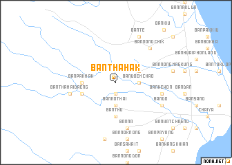
Ban Tha Hak (Surat Thani, Thailand)Ban Tha Hak is a town in the Surat Thani region of Thailand. An overview map of the region around Ban Tha Hak is displayed below.
regional and 3d topo map of Ban Tha Hak, Thailand ::
Ban Tha Hak airports ::
The nearest airport is NST - Nakhon Si Thammarat Cha Ian, located 142.1 km south east of Ban Tha Hak.
Other airports nearby include HKT - Phuket Intl (169.5 km south west), TST - Trang (220.3 km south), Nearby towns ::
Ban Pak Chong (1.9km south) //
Ban Mo Thai (3.7km south) //
Ban Doem Chao (3.7km east) //
Ban Khao Phanom Baek (4.1km north east) //
Ban Pak Mak (5.5km west) //
Ban Thu (5.6km south) //
Ban Pak Phraek (5.8km west) //
Ban Na (7.6km south) //
Ban We Won (7.5km east) //
Ban Tha Mai Daeng (7.5km west) //
Ban Nong Chik (7.8km north east) //
Ban Do (8.2km south east) //
Ban Te (8.3km north east) //
Ban Kiu (11.5km north east) //
[all distances 'as the bird flies' and approximate] 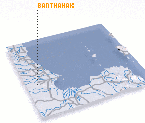 Places with similar names to Ban Tha Hak, Thailand ::
// Ban Thahou (2) (LA)
Disclaimer :: Information on this page comes without warranty of any kind |
||
|
Where is Ban Tha Hak? Elevation and coordinates ::
Latitude (lat): 9°26'0"N Longitude (lon): 99°6'0"E
Elevation (approx.): 29m (map arrows pan, magnifying glasses zoom) |
||
|
Visiting Ban Tha Hak? Hotel/Accommodation ::
Book a hotel in Ban Tha Hak Travel Guide ::
Buy a travel guide for Thailand rental cars ::
car rental offers GPS waypoint ::
download a GPX waypoint (PoI) of Ban Tha Hak for your GPS receiver
|
||