|
search place name
|
||
Ban Tha Kham Khwai (Satun, Thailand)Ban Tha Kham Khwai is a town in the Satun region of Thailand. An overview map of the region around Ban Tha Kham Khwai is displayed below.
regional and 3d topo map of Ban Tha Kham Khwai, Thailand ::

Ban Tha Kham Khwai airports ::
The nearest airport is TST - Trang, located 49.2 km north of Ban Tha Kham Khwai.
Other airports nearby include HDY - Songkhla Hat Yai Intl (74.1 km east), LGK - Pulau Langkawi Intl (83.1 km south), AOR - Alor Setar Sultan Abdul Halim (122.6 km south east), NST - Nakhon Si Thammarat Cha Ian (155.6 km north), Nearby towns ::
Ban Pria (2.0km south east) //
Thung Wa (3.8km north east) //
King Amphoe Thung Wa (4.2km south west) //
Ban Ma Ngang (4.5km west) //
Ban Thung Wa (5.0km north east) //
Ban Thung Thanan (5.5km south west) //
Ban Khum Sap (6.0km south east) //
Ban Li Phang (6.3km north west) //
Ban Lao Trong (7.2km north west) //
Ban Thung Bu Lang (8.1km south west) //
Ban Yong Sata (8.4km north west) //
Ban Thong Din Lum (8.8km east) //
Ban Thung Sa Bo (9.4km south west) //
Ban Khon Khlan (9.4km south west) //
[all distances 'as the bird flies' and approximate] 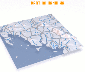 Places with similar names to Ban Tha Kham Khwai, Thailand :: Disclaimer :: Information on this page comes without warranty of any kind |
||
|
Where is Ban Tha Kham Khwai? Elevation and coordinates ::
Latitude (lat): 7°4'51"N Longitude (lon): 99°44'19"E
Elevation (approx.): 7m (map arrows pan, magnifying glasses zoom) |
||
|
Visiting Ban Tha Kham Khwai? Hotel/Accommodation ::
Book a hotel in Ban Tha Kham Khwai Travel Guide ::
Buy a travel guide for Thailand rental cars ::
car rental offers GPS waypoint ::
download a GPX waypoint (PoI) of Ban Tha Kham Khwai for your GPS receiver
|
||