|
search place name
|
||
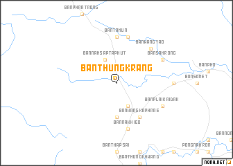
Ban Thung Krang (Chanthaburi, Thailand)Ban Thung Krang is a town in the Chanthaburi region of Thailand. An overview map of the region around Ban Thung Krang is displayed below.
regional and 3d topo map of Ban Thung Krang, Thailand ::
Ban Thung Krang airports ::
The nearest airport is UTP - Rayong U Taphao Intl, located 141.9 km west of Ban Thung Krang.
Other airports nearby include REP - Siem-reap Siem Reap (173.2 km east), BKK - Bangkok Intl (205.3 km north west), NAK - Nakhon Ratchasima Khorat (213.2 km north), Nearby towns ::
Ban Nam Sap Ta Phut (4.1km north west) //
Ban Phangngon (4.1km south east) //
Ban Thalu (5.6km south) //
Ban Wang Kaphrae (6.6km south east) //
Ban Rakam (7.4km north) //
Ban Ta Mun (7.4km north) //
Ban Don Chen (7.6km north) //
Ban Na Khieo (7.6km south) //
Ban Wang Yao (7.8km north east) //
Ban Samrong (8.1km north east) //
Ban Plai Kai Dak (8.1km south east) //
[all distances 'as the bird flies' and approximate] 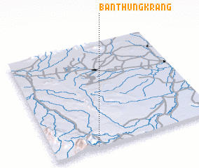 Places with similar names to Ban Thung Krang, Thailand ::
// Ban Thong Kreng (TH)
Disclaimer :: Information on this page comes without warranty of any kind |
||
|
Where is Ban Thung Krang? Elevation and coordinates ::
Latitude (lat): 13°1'0"N Longitude (lon): 102°16'0"E
Elevation (approx.): 220m (map arrows pan, magnifying glasses zoom) |
||
|
Visiting Ban Thung Krang? Hotel/Accommodation ::
Book a hotel in Ban Thung Krang Travel Guide ::
Buy a travel guide for Thailand rental cars ::
car rental offers GPS waypoint ::
download a GPX waypoint (PoI) of Ban Thung Krang for your GPS receiver
|
||