|
search place name
|
||
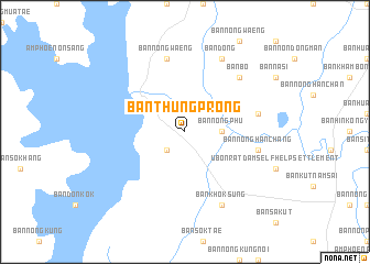
Ban Thung Prong (Khon Kaen, Thailand)Ban Thung Prong is a town in the Khon Kaen region of Thailand. An overview map of the region around Ban Thung Prong is displayed below.
regional and 3d topo map of Ban Thung Prong, Thailand ::
Ban Thung Prong airports ::
The nearest airport is UTH - Udon Thani, located 73.4 km north of Ban Thung Prong.
Other airports nearby include LOE - Loei (127.3 km north west), VTE - Vientiane Wattay Intl (139.3 km north), SNO - Sakon Nakhon (162.9 km east), NAK - Nakhon Ratchasima Khorat (208.8 km south), Nearby towns ::
Ban Nong O (2.6km south west) //
Ban Dong (2.6km south west) //
Ban Bo (2.6km south west) //
Ban Nong Phu (3.5km east) //
Ban Nong Han Chang (7.3km east) //
Ban Kham Bon (7.3km east) //
Ban Nong O (7.3km east) //
Ban Nong Waeng (7.6km north) //
Ban Bo (7.7km north east) //
Ban Khok Sung (8.2km south east) //
Ban Dong (8.2km north east) //
[all distances 'as the bird flies' and approximate] 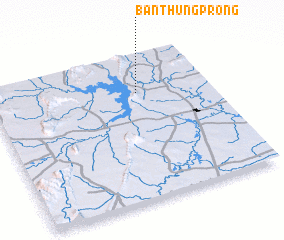 Places with similar names to Ban Thung Prong, Thailand ::
// Ban Thung Prong (TH)
// Ban Thung Prong (TH)
Disclaimer :: Information on this page comes without warranty of any kind |
||
|
Where is Ban Thung Prong? Elevation and coordinates ::
Latitude (lat): 16°44'0"N Longitude (lon): 102°40'0"E
Elevation (approx.): 198m (map arrows pan, magnifying glasses zoom) |
||
|
Visiting Ban Thung Prong? Hotel/Accommodation ::
Book a hotel in Ban Thung Prong Travel Guide ::
Buy a travel guide for Thailand rental cars ::
car rental offers GPS waypoint ::
download a GPX waypoint (PoI) of Ban Thung Prong for your GPS receiver
|
||