|
search place name
|
||
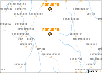
Ban Waen (Thailand)Ban Waen is a town in Thailand. An overview map of the region around Ban Waen is displayed below.
regional and 3d topo map of Ban Waen, Thailand ::
Ban Waen airports ::
The nearest airport is THL - Tachilek Tachileik, located 129.3 km north of Ban Waen.
Other airports nearby include PRH - Phrae (135.0 km south), LPT - Lampang (142.0 km south west), MOG - Mong Hsat (164.7 km north west), LPQ - Luang Prabang Luang Phabang Intl (211.1 km east), Nearby towns ::
Ban That (6.6km south west) //
Ban Don Mun (6.4km south west) //
Ban Mae Wang Chang (7.4km south) //
Ban Kot (7.2km west) //
Ban Huai Chun (8.9km south west) //
Ban Huai Chun (8.9km south west) //
Ban Huai Khrai (9.1km north west) //
Ban Waen Khong (1) (8.9km north east) //
[all distances 'as the bird flies' and approximate]  Places with similar names to Ban Waen, Thailand ::
// Banawon (PH)
// Bonawon (PH)
// Bunawan (PH)
// Binawian (IQ)
// Ban Ai Waen (TH)
// Ban Na Waen (TH)
// Ban Na Wan (TH)
// Ban Na Wa Noi (TH)
// Ban Wa En (TH)
// Ban Waen (TH)
Disclaimer :: Information on this page comes without warranty of any kind |
||
|
Where is Ban Waen? Elevation and coordinates ::
Latitude (lat): 19°21'0"N Longitude (lon): 100°14'0"E
Elevation (approx.): 774m (map arrows pan, magnifying glasses zoom) |
||
|
Visiting Ban Waen? Hotel/Accommodation ::
Book a hotel in Ban Waen Travel Guide ::
Buy a travel guide for Thailand rental cars ::
car rental offers GPS waypoint ::
download a GPX waypoint (PoI) of Ban Waen for your GPS receiver
|
||