|
search place name
|
||
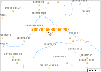
Ban Yang Khun Sapok (Chiang Mai, Thailand)Ban Yang Khun Sapok is a town in the Chiang Mai region of Thailand. An overview map of the region around Ban Yang Khun Sapok is displayed below.
regional and 3d topo map of Ban Yang Khun Sapok, Thailand ::
Ban Yang Khun Sapok airports ::
The nearest airport is LPT - Lampang, located 109.1 km south east of Ban Yang Khun Sapok.
Other airports nearby include PRH - Phrae (179.7 km east), MOG - Mong Hsat (216.7 km north), THL - Tachilek Tachileik (246.8 km north east), PHS - Phitsanulok (277.4 km south east), Nearby towns ::
Ban Huai Tong (1.4km north) //
Ban Nong Tao (2.0km north west) //
Ban Pong Noi (4.1km south) //
Ban Huai Sai (4.5km north) //
Ban Thung Luang (5.8km north) //
Ban Yang Pung Samit (6.1km north west) //
Ban Huai Khao Lip (7.1km north) //
Ban Mae Sapok Nua (6.8km east) //
Ban Pong Samit (8.4km north west) //
Ban Mae Sapok Noi (8.1km east) //
Ban Yang Puai (9.4km south) //
[all distances 'as the bird flies' and approximate] 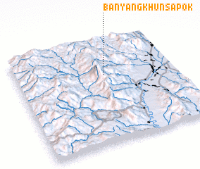 Places with similar names to Ban Yang Khun Sapok, Thailand :: Disclaimer :: Information on this page comes without warranty of any kind |
||
|
Where is Ban Yang Khun Sapok? Elevation and coordinates ::
Latitude (lat): 18°40'25"N Longitude (lon): 98°33'42"E
Elevation (approx.): 967m (map arrows pan, magnifying glasses zoom) |
||
|
Visiting Ban Yang Khun Sapok? Hotel/Accommodation ::
Book a hotel in Ban Yang Khun Sapok Travel Guide ::
Buy a travel guide for Thailand rental cars ::
car rental offers GPS waypoint ::
download a GPX waypoint (PoI) of Ban Yang Khun Sapok for your GPS receiver
|
||