|
search place name
|
||
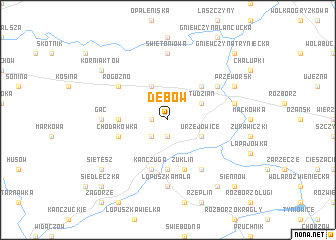
Dębów (Poland)Dębów is a town in Poland. An overview map of the region around Dębów is displayed below.
regional and 3d topo map of Dębów, Poland ::
Dębów airports ::
The nearest airport is RZE - Rzeszow Jasionka, located 30.9 km west of Dębów.
Other airports nearby include LWO - Lvov Lviv Intl (112.1 km east), KSC - Kosice (175.3 km south west), Nearby towns ::
Mikulice (1.9km south) //
Wolica (1.2km west) //
Ostrów (2.2km south west) //
Nowosielce (3.9km north) //
Urzejowice (3.0km south east) //
Studzian (3.0km north east) //
Grzęska (4.4km north east) //
Białoboki (3.6km west) //
Niżatyce (5.6km south) //
Chodakówka (4.0km south west) //
Kańczuga (5.7km south) //
Żuklin (5.7km south) //
Rogóźno (5.1km north west) //
Gorliczyna (5.1km north east) //
Krzeczowice (6.0km south east) //
Gać (4.8km west) //
Łopuszka Mała (7.4km south) //
Świętoniowa (7.4km north) //
Budy Przeworsk (5.1km east) //
Mokra Strona (5.1km east) //
Przeworsk (6.0km north east) //
Korniaktów (7.3km north west) //
Sietesz (7.3km south west) //
Bóbrka Kańczudska (8.2km south east) //
Siedleczka (8.8km south west) //
Siennów (8.8km south east) //
Gniewczyna Tryniecka (8.8km north east) //
[all distances 'as the bird flies' and approximate]  Places with similar names to Dębów, Poland ::
Disclaimer :: Information on this page comes without warranty of any kind |
||
|
Where is Dębów? Elevation and coordinates ::
Latitude (lat): 50°2'0"N Longitude (lon): 22°26'0"E
Elevation (approx.): 204m (map arrows pan, magnifying glasses zoom) |
||
|
Visiting Dębów? Hotel/Accommodation ::
Book a hotel in Dębów Travel Guide ::
Buy a travel guide for Poland rental cars ::
car rental offers GPS waypoint ::
download a GPX waypoint (PoI) of Dębów for your GPS receiver
|
||