|
search place name
|
||
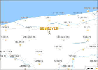
Dobrzyca (Koszalin, Poland)Dobrzyca is a town in the Koszalin region of Poland. An overview map of the region around Dobrzyca is displayed below.
regional and 3d topo map of Dobrzyca, Poland ::
Dobrzyca airports ::
The nearest airport is OSP - Slupsk Redzikowo, located 84.2 km north east of Dobrzyca.
Other airports nearby include SZZ - Szczechin Goleniow (94.3 km south west), RNN - Bornholm Ronne (123.2 km north west), POZ - Poznan Lawica (205.3 km south), KID - Kristianstad (226.1 km north west), Nearby towns ::
Gąski (5.6km north) //
Wierzchomino (3.7km south east) //
Warnino (6.0km south) //
Strachomino (4.7km south west) //
Tymień (4.7km north west) //
Mierzyn (7.7km south) //
Będzino (5.7km north east) //
Sarbinowo (7.7km north) //
Chłopy (8.6km north east) //
[all distances 'as the bird flies' and approximate] 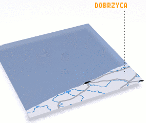 Places with similar names to Dobrzyca, Poland ::
// Tabarsuk (RU)
// Doberschau (DE)
// Dąbrowskie (PL)
// Dąbrowskie (PL)
// Dobrskie (PL)
// Dobrzec (PL)
// Dobrzyca (PL)
// Dobrzyca (PL)
// Dobrzyki (PL)
// Dobrzyków (PL)
Disclaimer :: Information on this page comes without warranty of any kind |
||
|
Where is Dobrzyca? Elevation and coordinates ::
Latitude (lat): 54°11'0"N Longitude (lon): 15°55'0"E
Elevation (approx.): 22m (map arrows pan, magnifying glasses zoom) |
||
|
Visiting Dobrzyca? Hotel/Accommodation ::
Book a hotel in Dobrzyca Travel Guide ::
Buy a travel guide for Poland rental cars ::
car rental offers GPS waypoint ::
download a GPX waypoint (PoI) of Dobrzyca for your GPS receiver
|
||