|
search place name
|
||
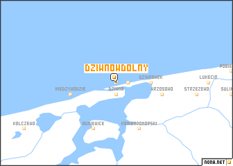
Dziwnów Dolny (Koszalin, Poland)Dziwnów Dolny is a town in the Koszalin region of Poland. An overview map of the region around Dziwnów Dolny is displayed below.
regional and 3d topo map of Dziwnów Dolny, Poland ::
Dziwnów Dolny airports ::
The nearest airport is SZZ - Szczechin Goleniow, located 50.9 km south of Dziwnów Dolny.
Other airports nearby include RNN - Bornholm Ronne (114.6 km north), MMX - Malmoe Sturup (188.8 km north west), TXL - Berlin Tegel (190.8 km south west), THF - Berlin Tempelhof (195.5 km south west), Nearby towns ::
Dziwnów (0.0km north) //
Dziwna (1.9km south) //
Dziwnów Górny (1.1km east) //
Dziwnówek (3.3km east) //
Międzywodzie (4.7km south west) //
Wrzosowo (4.7km south east) //
Buniewice (7.7km south) //
Kamień Pomorski (7.7km south) //
[all distances 'as the bird flies' and approximate] 
Disclaimer :: Information on this page comes without warranty of any kind |
||
|
Where is Dziwnów Dolny? Elevation and coordinates ::
Latitude (lat): 54°2'0"N Longitude (lon): 14°45'0"E
Elevation (approx.): -32768m (map arrows pan, magnifying glasses zoom) |
||
|
Visiting Dziwnów Dolny? Hotel/Accommodation ::
Book a hotel in Dziwnów Dolny Travel Guide ::
Buy a travel guide for Poland rental cars ::
car rental offers GPS waypoint ::
download a GPX waypoint (PoI) of Dziwnów Dolny for your GPS receiver
|
||