|
search place name
|
||
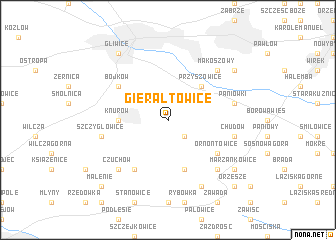
Gierałtowice (Poland)Gierałtowice is a town in Poland. An overview map of the region around Gierałtowice is displayed below.
regional and 3d topo map of Gierałtowice, Poland ::
Gierałtowice airports ::
The nearest airport is KTW - Katowice Pyrzowice, located 38.6 km north east of Gierałtowice.
Other airports nearby include OSR - Ostrava Mosnov (72.4 km south west), KRK - Krakow Balice (77.9 km east), PRV - Prerov (129.0 km south west), WRO - Wroclaw Strachowice (162.7 km north west), Nearby towns ::
Beksza (2.2km south east) //
Przyszowice (4.4km north east) //
Knurów (3.6km west) //
Dębieńsko Wielkie (5.7km south) //
Bojków (5.1km north west) //
Ornontowice (5.1km south east) //
Ameryka (6.0km south west) //
Czerwionka (6.0km south west) //
Paniówki (5.1km east) //
Chudów (5.1km east) //
Szczygłowice (5.1km west) //
Krywałd (5.1km west) //
Maria (6.6km south east) //
Czuchów (6.6km south west) //
Makoszowy (6.6km north east) //
Jaśkowice (7.8km south) //
Marzankowice (7.3km south east) //
Kończyce (7.3km north east) //
Gliwice (8.2km north west) //
Orzesze (8.8km south east) //
Malenie (8.8km south west) //
[all distances 'as the bird flies' and approximate]  Places with similar names to Gierałtowice, Poland ::
// Gierałtowice (PL)
Disclaimer :: Information on this page comes without warranty of any kind |
||
|
Where is Gierałtowice? Elevation and coordinates ::
Latitude (lat): 50°13'0"N Longitude (lon): 18°43'0"E
Elevation (approx.): 236m (map arrows pan, magnifying glasses zoom) |
||
|
Visiting Gierałtowice? Hotel/Accommodation ::
Book a hotel in Gierałtowice Travel Guide ::
Buy a travel guide for Poland rental cars ::
car rental offers GPS waypoint ::
download a GPX waypoint (PoI) of Gierałtowice for your GPS receiver
|
||