|
search place name
|
||
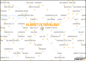
Kłopoty Stanisławy (Poland)Kłopoty Stanisławy is a town in Poland. An overview map of the region around Kłopoty Stanisławy is displayed below.
regional and 3d topo map of Kłopoty Stanisławy, Poland ::
Kłopoty Stanisławy airports ::
The nearest airport is WAW - Warsaw Okecie, located 130.9 km west of Kłopoty Stanisławy.
Nearby towns ::
Krynki Sobole (2.2km north west) //
Kłopoty Bujny (2.2km south east) //
Kłopoty Patry (2.3km east) //
Moczydły Lachowskie (2.3km west) //
Moczydły Stare (2.3km west) //
Moczydły (2.3km west) //
Krasewice Czerepy (3.7km south) //
Kułygi (3.7km south) //
Biszewo (3.9km north) //
Lachówka (2.9km south east) //
Zalesie (2.9km south west) //
Krasewice Stare (3.9km south) //
Krasewice Jagiełki (3.9km south) //
Malinowo (4.3km north east) //
Rybałty (4.3km north west) //
Aleksandrowo (5.6km north) //
Czarna Wielkie (6.0km north) //
Niewiarowo Sochy (5.0km north west) //
Makarki (6.0km north) //
Czartajew (6.0km south) //
Cecele (6.0km south) //
Skiwy (5.0km south west) //
Wyromiejki (5.0km south east) //
Morze (4.5km west) //
Wiercień Mały (4.9km east) //
Klukowo (7.5km south) //
Korzeniówka (6.5km south west) //
Lipiny (5.8km north east) //
Niewiarowo Przybki (7.2km north west) //
[all distances 'as the bird flies' and approximate]  Places with similar names to Kłopoty Stanisławy, Poland :: Disclaimer :: Information on this page comes without warranty of any kind |
||
|
Where is Kłopoty Stanisławy? Elevation and coordinates ::
Latitude (lat): 52°31'0"N Longitude (lon): 22°48'0"E
Elevation (approx.): 166m (map arrows pan, magnifying glasses zoom) |
||
|
Visiting Kłopoty Stanisławy? Hotel/Accommodation ::
Book a hotel in Kłopoty Stanisławy Travel Guide ::
Buy a travel guide for Poland rental cars ::
car rental offers GPS waypoint ::
download a GPX waypoint (PoI) of Kłopoty Stanisławy for your GPS receiver
|
||