|
search place name
|
||
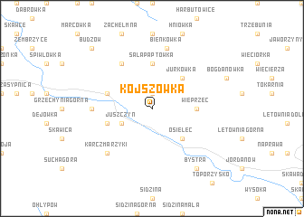
Kojszówka (Poland)Kojszówka is a town in Poland. An overview map of the region around Kojszówka is displayed below.
regional and 3d topo map of Kojszówka, Poland ::
Kojszówka airports ::
The nearest airport is KRK - Krakow Balice, located 40.3 km north of Kojszówka.
Other airports nearby include TAT - Poprad Tatry (80.5 km south east), KTW - Katowice Pyrzowice (96.4 km north west), OSR - Ostrava Mosnov (117.0 km west), SLD - Sliac (127.7 km south), Nearby towns ::
Żarnówka (1.9km north) //
Juszczyn (3.0km south west) //
Jurkówka (4.4km north east) //
Osielec (4.4km south east) //
Wieprzec (3.6km east) //
Sałapaptówka (5.6km north) //
Maków Podhalański (4.0km north west) //
Biała (4.0km south west) //
Jachówka (6.1km north west) //
Grzechynia (4.8km west) //
Bieńkówka (7.5km north) //
Karczmarzyki (6.6km south west) //
Bystra (8.2km south east) //
Budzów (8.8km north west) //
[all distances 'as the bird flies' and approximate] 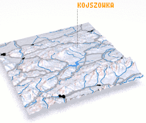 Places with similar names to Kojszówka, Poland :: Disclaimer :: Information on this page comes without warranty of any kind |
||
|
Where is Kojszówka? Elevation and coordinates ::
Latitude (lat): 49°43'0"N Longitude (lon): 19°44'0"E
Elevation (approx.): 658m (map arrows pan, magnifying glasses zoom) |
||
|
Visiting Kojszówka? Hotel/Accommodation ::
Book a hotel in Kojszówka Travel Guide ::
Buy a travel guide for Poland rental cars ::
car rental offers GPS waypoint ::
download a GPX waypoint (PoI) of Kojszówka for your GPS receiver
|
||