|
search place name
|
||
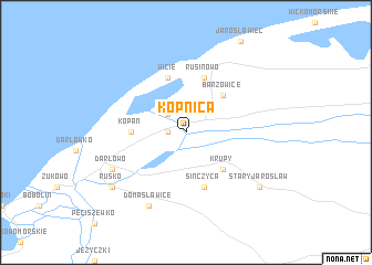
Kopnica (Koszalin, Poland)Kopnica is a town in the Koszalin region of Poland. An overview map of the region around Kopnica is displayed below.
regional and 3d topo map of Kopnica, Poland ::
Kopnica airports ::
The nearest airport is OSP - Slupsk Redzikowo, located 40.6 km east of Kopnica.
Other airports nearby include GDN - Gdansk Lecha Walesy (129.0 km east), RNN - Bornholm Ronne (130.3 km north west), SZZ - Szczechin Goleniow (141.5 km south west), RNB - Ronneby (216.5 km north), Nearby towns ::
Zakrzewo (1.1km west) //
Palczewice (2.1km north west) //
Barzowice (4.3km north east) //
Krupy (4.3km south east) //
Kopań (3.2km west) //
Cisowo (3.2km west) //
Wicie (5.7km north) //
Rusinowo (5.7km north) //
Sińczyca (5.7km south) //
Darłowo (5.7km south west) //
Domasławice (7.7km south) //
Rusko (7.0km south west) //
Stary Jarosław (7.0km south east) //
[all distances 'as the bird flies' and approximate] 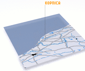 Places with similar names to Kopnica, Poland ::
Disclaimer :: Information on this page comes without warranty of any kind |
||
|
Where is Kopnica? Elevation and coordinates ::
Latitude (lat): 54°27'0"N Longitude (lon): 16°29'0"E
Elevation (approx.): 2m (map arrows pan, magnifying glasses zoom) |
||
|
Visiting Kopnica? Hotel/Accommodation ::
Book a hotel in Kopnica Travel Guide ::
Buy a travel guide for Poland rental cars ::
car rental offers GPS waypoint ::
download a GPX waypoint (PoI) of Kopnica for your GPS receiver
|
||