|
search place name
|
||
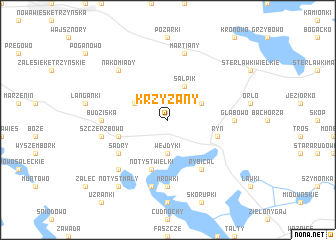
Krzyżany (Poland)Krzyżany is a town in Poland. An overview map of the region around Krzyżany is displayed below.
regional and 3d topo map of Krzyżany, Poland ::
Krzyżany airports ::
The nearest airport is KGD - Kaliningrad Khrabrovo, located 118.5 km north west of Krzyżany.
Other airports nearby include WAW - Warsaw Okecie (203.6 km south), Nearby towns ::
Wejdyki (3.7km south) //
Knis (2.9km north east) //
Koczarki (2.9km north west) //
Salpik (3.9km north) //
Notyst Wielki (5.7km south) //
Ryn (3.8km south east) //
Słabowo (3.8km south west) //
Rybical (6.0km south) //
Sądry (4.9km south west) //
Budziska (4.4km west) //
Głąbowo (4.4km east) //
Mrówki (7.4km south) //
Martiany (7.5km north) //
Szczerzbowo (4.7km south west) //
Notyst Dolny (7.5km south) //
Mierzejewo (6.5km south west) //
Nakomiady (6.4km north west) //
Notyst Mały (8.1km south west) //
[all distances 'as the bird flies' and approximate]  Places with similar names to Krzyżany, Poland ::
// Greßhausen (DE)
// Großhausen (DE)
// Grosshausen (DE)
// Großsüßen (DE)
// Kra Sae Sin (TH)
// Chrzęsne (PL)
// Gruszewnia (PL)
// Korycizna (PL)
// Krasocin (PL)
// Kraszew Nowy (PL)
Disclaimer :: Information on this page comes without warranty of any kind |
||
|
Where is Krzyżany? Elevation and coordinates ::
Latitude (lat): 53°58'0"N Longitude (lon): 21°30'0"E
Elevation (approx.): 154m (map arrows pan, magnifying glasses zoom) |
||
|
Visiting Krzyżany? Hotel/Accommodation ::
Book a hotel in Krzyżany Travel Guide ::
Buy a travel guide for Poland rental cars ::
car rental offers GPS waypoint ::
download a GPX waypoint (PoI) of Krzyżany for your GPS receiver
|
||