|
search place name
|
||
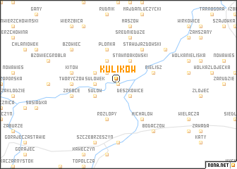
Kulików (Poland)Kulików is a town in Poland. An overview map of the region around Kulików is displayed below.
regional and 3d topo map of Kulików, Poland ::
Kulików airports ::
The nearest airport is RZE - Rzeszow Jasionka, located 102.3 km south west of Kulików.
Other airports nearby include LWO - Lvov Lviv Intl (127.7 km south east), Nearby towns ::
Nawóz (0.0km north) //
Deszkowice (2.2km south east) //
Gruszka Mała (2.2km north west) //
Sułówek (2.3km west) //
Sułów (3.0km south west) //
Gruszka Duża (3.0km north west) //
Nowa Wieś (3.9km north) //
Staw Noakowski (3.9km north) //
Płonka (5.7km north) //
Nielisz (4.0km north east) //
Rozłopy (5.7km south) //
Średnie Małe (6.0km north east) //
Staw Ujazdowski (6.0km north east) //
Klemensów (6.0km south east) //
Michałów (6.0km south east) //
Tworyczów (4.7km west) //
Żrebce (5.0km west) //
Kolonia Sułów (5.0km west) //
Kitów (5.0km west) //
Średnie Duże (7.5km north) //
Bodaczów (8.2km south east) //
Kolonia Staw Noakowski (7.3km north east) //
Bzowiec (7.3km north west) //
[all distances 'as the bird flies' and approximate] 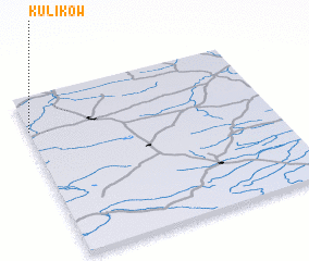 Places with similar names to Kulików, Poland ::
Disclaimer :: Information on this page comes without warranty of any kind |
||
|
Where is Kulików? Elevation and coordinates ::
Latitude (lat): 50°47'0"N Longitude (lon): 23°0'0"E
Elevation (approx.): 191m (map arrows pan, magnifying glasses zoom) |
||
|
Visiting Kulików? Hotel/Accommodation ::
Book a hotel in Kulików Travel Guide ::
Buy a travel guide for Poland rental cars ::
car rental offers GPS waypoint ::
download a GPX waypoint (PoI) of Kulików for your GPS receiver
|
||